Chapter 1 Nature's driver
Chapter 1 Nature's driver
Water is the driver of Nature.
Leonardo da Vinci(1452-1519)
(Italian painter,architect,and engineer)
We live on a wet planet.Water is the most abundant substance on Earth and covers two-thirds of its surface.It is also found in smaller quantities in the air we breathe,the plants and animals we see,and the ground on which we tread.This water is continuously on the move,being recycled between the land,oceans,and atmosphere:an eternal succession known as the hydrological cycle.Rivers play a key role in the hydrological cycle,draining water from the land and moving it ultimately to the sea.
Any rain or melted snow that doesn't evaporate or seep into the earth flows downhill over the land surface under the influence of gravity.This flow is channelled by small irregularities in the topography into rivulets that merge to become gullies that feed into larger channels.The flow of rivers is augmented with water flowing through the soil and from underground stores,but a river is more than simply water flowing to the sea.A river also carries rocks and other sediments,dissolved minerals,plants,and animals,both dead and alive.In doing so,rivers transport large amounts of material and provide habitats for a great variety of wildlife.They carve valleys and deposit plains,being largely responsible for shaping the Earth's continental landscapes.
Rivers change progressively over their course from headwaters to mouth,from steep streams that are narrow and turbulent to wider,deeper,often meandering channels.From upstream to downstream,a continuum of change occurs:the volume of water flowing usually increases and coarse sediments grade into finer material.In its upper reaches,a river erodes its bed and banks,but this removal of earth,pebbles,and sometimes boulders gives way to the deposition of material in lower reaches.In tune with these variations in the physical characteristics of the river,changes can also be seen in the types of creatures and plants that make the river their home.
Its narrow,linear form and its flow in just one direction provide an obvious spatial dimension to how we should describe and understand the physical,chemical,and biological properties of a river:horizontally from upstream to downstream.But a river is not just a channel.It is also an integral part of the countryside through which it flows,so a lateral dimension,to the surrounding landscape,is also appropriate.The links with the landscape,or riverscape as some would prefer,are innumerable.They range from the simple fact that most water in a river arrives in the channel after flowing across the surrounding topography to the importance of salmon in a river,say,as a seasonal source of food for local bears.
A third dimension is vertical.Rivers interact with the sediments beneath the channel and with the air above.The water flowing in many rivers comes both directly from the air as rainfall-or another form of precipitation-and also from groundwater sources held in rocks and gravels beneath,both being flows of water through the hydrological cycle.
The vital fourth dimension,time,also has an important place in river research.This is because of profound variations in many factors that affect rivers,not least the amount of water flowing in them.This varies on a wide range of timescales,from an intense rainstorm that lasts less than an hour to the effects of tectonic forces that operate over many millions of years.
Rivers are found all over the world and have left their mark on virtually every landscape.Certain areas lack surface drainage,but in some of these regions rivers flow beneath the land surface.In deserts,many rivers remain dry for most of the year,only channelling water in response to a sporadic rainstorm.Elsewhere,fossil channels and valleys indicate where rivers have flowed at some time in the more distant past.Such fossilized features also occur on other planets:channels and valleys have been identified on Mars and on Titan-the largest of Saturn's moons-and these networks are remarkably similar to river and stream features on Earth.On the surface of Mars,these features have been sculpted by flowing water in times past,but the river channels and drainage networks on Titan are thought to have been formed by the flow of liquid methane.For most of our planet's land surface,a flowing river of water is one of the most fundamental elements.Supplied with energy from sunlight and gravity,it is a feature that moulds valleys and slopes and provides a complex habitat for living communities.
River hierarchies
One interesting aspect of rivers is that they seem to be organized hierarchically.When viewed from an aircraft or on a map,rivers form distinct networks like the branches of a tree.Small tributary channels join together to form larger channels which in turn merge to form still larger rivers.This progressive increase in river size is often described using a numerical ordering scheme in which the smallest stream is called first order,the union of two first-order channels produces a second-order river,the union of two second-order channels produces a third-order river,and so on.Stream order only increases when two channels of the same rank merge.Very large rivers,such as the Nile and Mississippi,are tenth-order rivers;the Amazon twelfth order.
Each river drains an area of land that is proportional to its size.
This area is known by several different terms:drainage basin,river basin,or catchment(‘watershed’is also used in American English,but this word means the drainage divide between two adjacent basins in British English).In the same way that a river network is made up of a hierarchy of low-order rivers nested within higher-order rivers,their drainage basins also fit together to form a nested hierarchy.In other words,smaller units are repeating elements nested within larger units.All of these units are linked by flows of water,sediment,and energy.
Recognizing rivers as being made up of a series of units that are arranged hierarchically provides a potent framework in which to study the patterns and processes associated with rivers.At the largest scale,the entire river basin can be studied.Within the basin,at progressively smaller scales,a researcher may focus on a particular segment of a river between tributaries,a reach within a segment,and so on all the way down to a small patch of sand grains on the river bed.This hierarchical approach also emphasizes that processes operating at the upper levels of the hierarchy exert considerable influence over features lower down in the hierarchy,but not the other way around.At the river basin scale,important factors are climate,geology,vegetation,and topography.These factors have an influence at all lesser scales,down to the small patch of sand grains.That patch of sand also comes under other local influences,such as ripples in the flowing water,but these small variations in the current have a negligible impact on the drainage basin as a whole.
There is an appropriate timescale associated with related spatial scales and these too can be arranged into a hierarchy.Generally,the larger the spatial scale,the slower the processes and rates of change.Changes in climate and geology,for instance,occur on lengthy timescales,such as hundreds to millions of years.The ripples in the water operate on much shorter timescales:milliseconds to seconds.
It is also important to remember that,in general terms,as size increases,so too does the complexity of factors influencing the landscape and the river running through it.Hence,the small catchment of a first-order river channel,for example,may well occur on one rock type and lie within one climatic region.A larger catchment is more likely to span several rock types and climatic regions and is therefore more complex.
Types of river
The numerical ordering scheme detailed in the previous section is one of many attempts to classify rivers.There is an enormous variety of different types of river,or‘fluvial’system(from the Latin word fluvius,a river),when we extend our area of interest beyond the river channel to include the entire drainage basin.Each river classification depends on the perspective of the investigator and hence the aspect of greatest significance.A biologist may focus on the distribution of particular groups of organisms such as fish or aquatic plants.Different species may be associated with different types of topography and geology,for example,hence rivers maybe placed in categories such as‘mountainous’,‘upland’,‘lowland chalk’,‘lowland sandstone’,and‘lowland and upland clay’.Others have used selected chemical factors as a basis for classification.An example is pH,so rivers might be classed as being strongly acid,slightly acid,or alkaline.An authority concerned with nature conservation might combine all of these perspectives and more.A classification of rivers in England,Wales,and Scotland based on vegetation communities devised by the Nature Conservancy Council recognizes four main groups of rivers,ten types,and thirty-eight sub-types.
Another simple way of categorizing rivers is by size.Some authorities prefer the word‘stream’when referring to rivers at one end of the size spectrum.A large or big river(both words are in common use to signify the other end of the spectrum)is usually one with either a large drainage basin,a long course,one that transports a large volume of sediment,or has a great volume of water flowing in it.We have noted that there is a consistent relationship between river length and drainage basin area,although not between the other variables due to variations in basin geology,relief,and hydrology.Most people when asked to list the world's largest rivers would come up with a similar list for their top 10 or 20,but a perfect definition remains elusive.
The pattern formed in a landscape by a network of rivers is a familiar way of distinguishing between different types of river system.There are several common variations on the essentially treelike pattern of a drainage network,and various descriptive terms are used,including dendritic,radial,trellis,parallel,and rectangular.The primary influence on these patterns is the geology of the landscape.
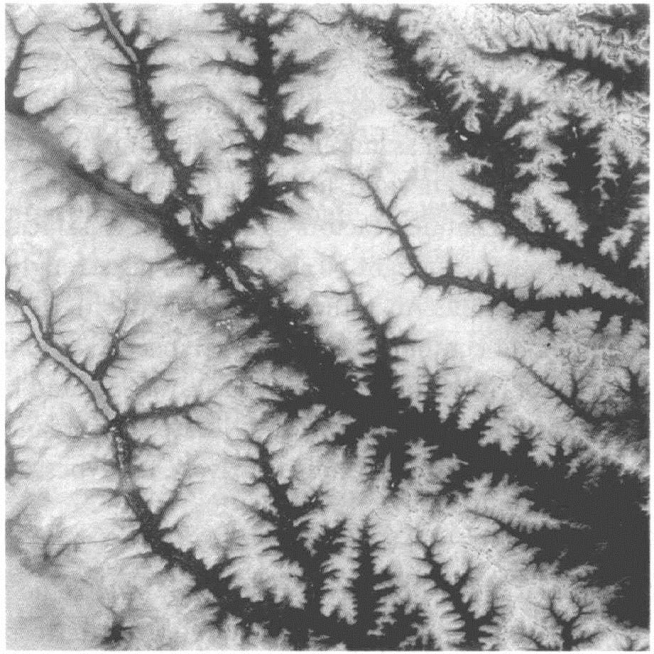
2.This satellite image of the Central Siberian Plateau illustrates atypical drainage network.Snow at higher altitudes contrasts with the snow-free valleys,helping to accentuate the drainage pattern
An obvious way of categorizing different types of river is by their types of flow.A river channel that carries water at all times throughout the year is described as‘perennial’,but this does not describe all rivers by any means.Some channels have water flowing in them only in particular seasons.These seasonal,or‘intermittent’,rivers may be in regions with a severe winter in which river water completely freezes,or in regions with a distinct wet season.A river with an even less permanent flow of water is described as‘ephemeral’and consists of channels that flow only for hours or days following individual rainstorms.Rivers that arise and flow in deserts are typically ephemeral rivers.A fourth category is the‘interrupted’river,one that has permanent flow over short reaches throughout the year while most of the river is dry.While these distinctions are undoubtedly real,like most classification schemes in the natural world,the boundaries between different classes are better viewed as points on a continuum of flow regime types.This is because,for example,during an extended wet period lasting several years,an ephemeral river may exhibit the characteristics of a seasonal river,while during dry periods,the wet season flow of a seasonal river maybe absent or more intermittent,making it appear more like an ephemeral river.
How long is a river?
Measuring the length of a river is more complicated than it sounds.Measurements and estimates for the length of the world's rivers vary greatly depending on all sorts of factors,including the season of the year,the abilities of the cartographer,and the quality of his equipment,as well as decisions about what exactly is measured.In theory,the exercise should be straightforward:determine the position of the source,identify the mouth,and accurately measure the length of the river between the two.Finding the mouth is usually clear-cut.Its exact location is commonly defined as the intersection between the central line of the river and a line drawn between the two sides of the outlet.
Determining the exact location of the source is often more difficult.Searches for the source of particular rivers in remote and inaccessible regions have intrigued and inspired explorers for centuries,and continue to do so even today.
Disagreements about the true source of many rivers have been a continuous feature of this history of exploration.In one sense,a mission to find‘the’source of a river is destined to be a matter of conjecture simply because most rivers typically have many ributaries and hence numerous sources.For most authorities,the source that is farthest away from the mouth is considered to be‘the’source of the river,thus giving a maximum river length.But,unsurprisingly,differences arise as to the farthest source.
Another complicating factor is whether or not to include tributaries that have been given different names.In practice,the series of decisions made about the inclusion or exclusion of tributaries is probably the major element of a quest to find the source of a river,and these decisions represent one of the central reasons why not all measurements for a particular river agree.Take the Mekong as an example.Everyone acknowledges that the river originates on the Tibetan Plateau,but where exactly is open to debate.Candidates for its source include glaciers on the Guozongmucha Mountain,Lasaigongma Mountain,Zhanarigen Mountain,Chajiarima Mountain,and Mount Jifu.Others include Rup-sa La Pass,Lungmo Pass,and Lake Zhaxiqiwa.Given the number of designated sources,perhaps it is not surprising that the Mekong is variously referred to as the ninth longest and the twelfth longest river in the world,and that is without going into similar confusion surrounding many of the other major world rivers.Respectable texts give the length of the Mekong as anything between 4,180 kilometres and 4,909 kilometres.If we accept that the river's source is on Mount Jifu,which many do not,the river has six names along its 4,909-kilometre length.On the flanks of Mount Jifu,melted snow and ice flow as a stream named the Guyong-Pudigao Creek(which only flows in the summer).After just over 20 kilometres,this becomes the Guoyong River,which becomes the Zhaa River.The Zhaa merges with the Zhana River to become the Zha River,which becomes the Lancang River until it reaches the Chinese border with Myanmar,where it is known as the Mekong all the way to its delta in southern Vietnam.In its delta,the river splits into several branches that flow into the South China Sea.
Some say this is the Mekong in its entirety,and that it is 4,909 kilometres long.Others agree that it is 4,909 kilometres long but say that strictly the river should be called the Mekong-Lancang-Zha-Zhaa-Guoyong-Guyong-Pudigao.Another group would prefer to deal only with the stretch that carries the name Mekong,in which case the river is actually just 2,711 kilometres long.Many others differ more profoundly because for them the source is not on Mount Jifu at all.
If you are bemused,it is understandable.But it gets more confusing.Some rivers do not have a mouth.The Okavango River in southern Africa gradually diminishes into the inland Okavango delta,the size of which varies with the seasons.Hence,the exact point where the river ends changes seasonally.Some rivers have more than one channel.The length of which channel should be measured in a‘braided’(see below)stretch of river?The timing of measurement is also important.Guyong-Pudigao Creek on Mount Jifu only has water flowing in it during the summer melt season.Should it be counted if the flow is not continuous?Another difficulty of timing occurs in rivers that flood seasonally.When large stretches of the Amazon,for example,flood in the wet season,water that flows round a meander in the dry season flows more directly‘overland’.Should the length of the meander be counted,or not?Over longer periods of time,rivers can create new land,by depositing sediment in deltas,for example,so increasing their length.
Yet another important part of measuring the length of a river is the scale at which it is measured.Fundamentally,the length of a river varies with the map scale because different amounts of detail are generalized at different scales.The terrain along the course of a river has great complexity,with details nested within details.
This geometric complexity,a quality known as‘fractal’that is inherent in many natural things,can be taken to the absurd.But when does a desire for greater detail cross the boundary into the realms of the absurd?
The use of satellite mapping,along with Global Positioning Systems(GPS),to establish accurate source locations will continue to improve our ability to study river systems in their entirety,but subjective decisions about the scale of study and which tributaries to include and exclude will continue to mean that it is effectively impossible to say definitively which river holds the‘world's longest’title.The Amazon and the Nile have been the main contenders for centuries as knowledge has improved and conventions have changed.The Scottish explorer John Hanning Speke thought he had solved one of the great mysteries of 19th-century world geography when he claimed in 1858 to have discovered that the source of the Nile was Lake Victoria.For much of the 20th century,most authorities recognized the Nile as the world's longest river,having added the longest tributary leading into Lake Victoria from the south.However,since the 1990s several credible claims have been made for the Amazon to be longer,following a number of expeditions in search of its source in the mountains of southern Peru.These claims put the length of the Amazon at some 6,850 kilometres,at least 150 kilometres longer than the Nile,but the debate is unlikely to end there.
River flow
Two particularly important properties of river flow are velocity and discharge-the volume of water moving past a point over some interval of time,although confusingly this may also be called simply the flow.A continuous record of discharge plotted against time is called a hydrograph which,depending on the time frame chosen,may give a detailed depiction of a flood event over a few days,or the discharge pattern over a year or more.
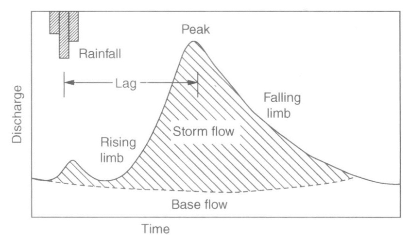
3.A storm hydrograph showing river discharge changing in responseto a rainfall event
Measuring the flow of rivers and analysing the records is important for evaluating water resources and the assessment of flood and drought hazards.No river has a longer hydrological record than the Nile,where a water-level gauging structure was built on Roda Island at Cairo in AD 641.The official in charge of the Roda‘nilometer’,the Sheikh el Mikyas,had the duty of observing the water level and during times of flood announcing the daily rise via public criers.This was always a tense time of year in Egypt.If the river did not reach a certain level,much cropland would go without water and famine could be expected,but at a certain higher level irrigation was assured,and with it taxes to the government.The position of Sheikh el Mikyas continued for more than 1,000 years.The last holder of the post died in 1947,and in the 1950s the Egyptian government decided to construct a major dam on the Nile at Aswan,thus significantly changing the country's intimate relationship with its river.The record from the Roda nilometer was invaluable in calculating the required storage capacity of the Aswan High Dam which was finally completed in 1970(see Chapter 5).
River flow is dependent upon many different factors,including the area and shape of the drainage basin.If all else is equal,larger basins experience larger flows.A river draining a circular basin tends to have a peak in flow because water from all its tributaries arrives at more or less the same time as compared to a river draining a long,narrow basin in which water arrives from tributaries in a more staggered manner.The surface conditions in a basin are also important.Vegetation,for example,intercepts rainfall and hence slows down its movement into rivers.
Climate is a particularly significant determinant of river flow.It is the major factor controlling the different types of flow identified above:perennial,intermittent,ephemeral,and interrupted.All the rivers with the greatest flows are almost entirely located in the humid tropics,where rainfall is abundant throughout the year.These are the Amazon,the Congo,and the Orinoco,each of which discharges more than 1,000 cubic kilometres of water into the oceans in an average year.
Rivers in the humid tropics experience relatively constant flows throughout the year,but perennial rivers in more seasonal climates exhibit marked seasonality in flow.The Indus River receives most of its water from the Himalayan mountains and the maximum summer discharge is over 100 times the winter minimum due to the effect of snowmelt.Minimum discharge is often zero in rivers flowing largely in areas of high latitude and high altitude,where temperatures fall below freezing point for a portion of the year.In these intermittent rivers,the distinct contrast between minimum flow during the frozen winter and great floods during the summer melt season is regular and predictable.
By contrast,the flow of ephemeral rivers,typically found in desert areas,is spasmodic and unpredictable.This is because ephemeral rivers respond to rainfall which is notoriously difficult to predict in many deserts.One study of a river bed in the northern Negev Desert in Israel showed that on average the channel contained water for just 2%of the time,or about seven days a year.Some desert rivers can go for an entire year without any flow.
Year-to-year variations in river flow are also greatest in dry climates,whereas perennial rivers in the humid tropics have relatively steady flows from one year to the next.Records of discharge in the middle reaches of the Kuiseb River in the Namib Desert in Namibia over several decades show that flow has varied from 0 to 102 days per year.
Over longer periods,changes in rainfall and temperature have also resulted in changes in river flow regimes,although human interference has confused the picture in many cases(see Chapter 5).One of the clearest recent changes in natural flows is in West Africa where the desert-marginal belt to the south of the Sahara known as the Sahel experienced a marked desiccation of the climate over the last few decades of the 20th century,a trend that has continued into the 21st century.The flow of the Senegal River measured at Bakel,near the meeting of the borders between Senegal,Mauritania,and Mali,showed a marked decline towards the end of the last century.The average annual discharge at Bakel for the period 1904-92 was 716 cubic metres per second,but that average was just 379 cubic metres per second over the period 1972-92.The flow in 1984,a particularly dry year,averaged out at 212 cubic metres per second.A similar picture has been seen on the Niger River.
Some rivers are large enough to flow through more than one climate region.Some desert rivers,for instance,are perennial because they receive most of their flow from high rainfall areas.outside the desert.These are known as‘exotic’rivers.The Nile is an example,as is the Murray in Australia.These rivers lose large amounts of water-by evaporation and infiltration into soils-while flowing through the desert,but their volumes are such that they maintain their continuity and reach the sea.By contrast,many exotic desert rivers do not flow into the sea but deliver their water to interior basins.In southern Africa,water from the tropical highlands in Angola flows in the Okavango River to the Okavango Delta,the large wetland area in the Kalahari Desert in northern Botswana.In central Asia,water from the Parmir Mountains flows into the Aral Sea via two of central Asia's major exotic rivers:the Syr Darya and Amu Darya.(https://www.daowen.com)
Some rivers are thought to be very old.Evidence from sediments deposited near the mouth of the Amazon suggests that the river has been flowing across South America for 11 million years.Over such great periods of time,all sorts of factors change,of course,and some rivers come and go.An example of a river that has disappeared is the Channel River which flowed westward in northwestern Europe some 20,000 years ago in the area now submerged beneath the English Channel separating Britain and France.This was the height of the last Ice Age,when sea levels all over the world were much lower than they are today because more water in the hydrological cycle was present as ice.Most of the British Isles and all of Scandinavia were covered in a thick ice sheet at this time,and the Channel River was fed by meltwater that flowed in the rivers of southern England,including the Thames and the Solent,that lay just beyond the permanent ice.Among the Channel River's other tributaries to the south were the Seine,Somme,Maas,Rhine,and Elbe.
Such ancient river channels are not solely of academic interest.The world's richest gold deposits,in the Witwatersrand district of South Africa,were laid down in river systems more than two billion years ago.Gold carried by these rivers was deposited in gravels where the velocity of the flowing water slowed.These gravels,known to geologists as Witwatersrand conglomerate,have produced nearly 50,000 tonnes,or 40%,of the gold ever mined,and probably still contain over one-third of the world's unmined gold reserves.Rivers have also played a key role in creating the valuable diamond deposits that stretch along the western coast of southern Africa.Diamonds have been eroded from deposits inland and carried to the coastline by the Vaal and Orange Rivers for 100 million years and more.This fluvial transport is also thought to be beneficial to the quality of the diamonds found in coastal sediments because the stones tend to break down during transport,increasing the concentration of higher-quality diamonds.
Erosion,transport,and deposition
An important measure of the way a river system moulds its landscape is the‘drainage density’.This is the sum of the channel length divided by the total area drained,which reflects the spacing of channels.Hence,drainage density expresses the degree to which a river dissects the landscape,effectively controlling the texture of relief.Numerous studies have shown that drainage density has a great range in different regions,depending on conditions of climate,vegetation,and geology particularly.The value tends to be high in arid regions of sparse vegetation,in temperate to tropical regions subjected to frequent heavy rains,and in areas underlain by rocks that are difficult for water to penetrate.
Rivers shape the Earth's continental landscapes in three main ways:by the erosion,transport,and deposition of sediments.These three processes have been used to recognize a simple three-part classification of individual rivers and river networks according to the dominant process in each of three areas:source,transfer,and depositional zones.
The first zone consists of the river's upper reaches,the area from which most of the water and sediment are derived.This is where most of the river's erosion occurs,and this eroded material is transported through the second zone to be deposited in the third zone.These three zones are idealized because some sediment is eroded,stored,and transported in each of them,but within each zone one process is dominant.
The changes in a river's slope that occur between its upper and lower reaches are reflected in a graphical measurement known as the‘long profile’.This is a section through the channel from its headwater to its mouth and is typically concave in shape because the headwaters are steep and slope decreases progressively in a downstream direction.This generally smooth,concave-upwards form is sometimes interrupted by outcrops of hard rocks that produce locally steeper slopes.Rapids form in these areas and the velocity of the river increases,promoting greater erosion,which over a long time period wears down the obstruction.In a place where relatively soft rocks are overlain by much more resistant rocks,a waterfall may occur.The world's highest waterfall,Angel Falls,or Kerepakupai Merú,cascades over a very hard sandstone rockface in Venezuela and is an awe-inspiring 979 metres in height.
All of the sediment carried by a river ultimately comes from the erosion of surrounding slopes and water flowing across and through the land surface,but the immediate supply comes from the bed and banks of the river channel.The flow of water carries this sediment in three ways:dissolved material-such as calcium,magnesium,and other minerals-moves in solution;small particles are carried in suspension;and larger particles are transported along the stream bed by rolling,sliding,or a bouncing movement known as‘saltation’.This material is deposited when circumstances change in some way,such as the slope of the river bed decreasing,so reducing the river's energy and ability to carry its load.Much of it is deposited in the sea.Globally,it is estimated that rivers transport around 15 billion tonnes of suspended material annually to the oceans,plus about another 4 billion tonnes of dissolved material.
In its upper reaches,a river might flow across bedrock but further downstream this is much less likely.Alluvial rivers are flanked by a floodplain,the channel cut into material that the river itself has transported and deposited.The floodplain is a relatively flat area which is periodically inundated during periods of high flow,typically every one or two years.When water spills out onto the floodplain,the velocity of flow decreases and sediment begins to settle,causing fresh deposits of alluvium on the floodplain.
Certain patterns of alluvial river channels have been seen on every continent and are divided at the most basic level into straight,meandering,and braided.Straight channels are rare in nature and,for the most part,are a function of the scale of assessment.They are described as straight at the regional scale,but at more local scales they are winding or sinuous to some degree.The most common river channel pattern is a series of bends known as meanders,named after the River Menderes in southwestern Turkey,which is well known for its sinuosity.Meanders develop because erosion becomes concentrated on the outside of a bend and deposition on the inside.As these linked processes continue,the meander bend can become more emphasized,and a particularly sinuous meander may eventually be cut off at its narrow neck,leaving an oxbow lake as evidence of its former course.Alluvial meanders migrate,both down and across their floodplain,a process that can be monitored by comparing old maps and repeated photography.This lateral migration is an important process in the formation of floodplains.
Braided rivers can be recognized by their numerous flows that split off and rejoin each other to give a braided appearance.These multiple intersecting flows are separated by small and often temporary islands of alluvium.Braided rivers typically carry abundant sediment and are found in areas with a fairly steep gradient,often near mountainous regions.The reason why one channel meanders and another is braided has been the subject of considerable research.Important factors that influence the channel pattern include the volume of water and velocity of flow,which are related in turn to the gradient of the channel and the nature of the channel,particularly the ease with which its bed and bank is eroded,which affects the supply of sediment to the river.These factors can change,over time and through space.For example,the Milk River in North America is a classic meandering river as it flows across southern Alberta in Canada but changes abruptly to a braided pattern shortly after entering Montana,USA.The change is probably due to differences in the material that makes up the bed and banks and a widening of the channel in the braided reach which reduces the power of the river.
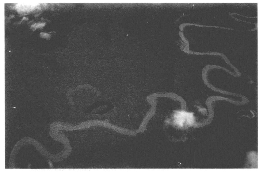
4.A meandering river and oxbow lakes in a remote part of NewGuinea
The meander cut-off creating an oxbow lake is one way in which a channel makes an abrupt change of course,a characteristic of some alluvial rivers that is generally referred to as‘avulsion’.It is a natural process by which flow diverts out of an established channel into a new permanent course on the adjacent floodplain,a change in course that can present a major threat to human activities.Rapid,frequent,and often significant avulsions have typified many rivers on the Indo-Gangetic plains of South Asia.In India,the Kosi River has migrated about 100 kilometres westward in the last 200 years,and the Gandak River has moved about 80 kilometres to the east over the last 5,000 years.The lower Indus River in Pakistan also has a history of major avulsions.Why a river suddenly avulses is not understood completely,but earthquakes play a part on the Indo-Gangetic plains.
Sometimes an avulsion can result in a channel being left dry,but on other occasions the channel becomes split,creating a river that flows in multiple channels.These multi-channel rivers are called‘anastomosing’or‘anabranching’rivers.At first sight,an anastomosing river can easily be confused with a braided river,which has a roughly comparable pattern.A braided river has multiple flows within a single channel,whereas an anastomosing river has multiple interconnected channels.Nonetheless,debates about the differences continue and numerous classifications of channel pattern are used.Misunderstandings can also arise when river flow is high or low.At high discharge,a braided river with submerged bars may look like a single-thread channel,and at low discharge an anastomosing river may carry water in a single main channel only,so appearing as a single-channel river.
Most rivers eventually flow into the sea or a lake,where they deposit sediment which builds up into a landform known as a delta.The name comes from the Greek letter delta,Δ,shaped like a triangle or fan,one of the classic shapes a delta can take.Examples of this type of delta include two of Africa's largest:those at the conclusion of the Niger and Nile Rivers.
The river provides the sediment that makes up a delta,but there are many other influences on its shape,including the volume of water flowing,the amount of sediment,and the relative importance of the flow of the river,the ebb and flow of tides,and the energy of waves.Fan-shaped deltas like the Niger and Nile are dominated by the action of the waves.Deltas dominated by the flow of the river typically extend further out into the sea as a lobe,its channels branching like the toes or claws of a bird.The Mississippi River delta is an example of the‘bird-foot delta’type.Tide-dominated deltas form in locations with a large tidal range or fast tidal currents.They are typified by numerous islands elongated parallel to the main tidal flow and perpendicular to the shore line.Good examples are the deltas of the Fly River in New Guinea and the delta at the confluence of the Brahmaputra and Ganges Rivers.Material laid down at the end of a river can continue underwater far beyond the delta as a deep-sea fan.The world's largest submarine fan lies beyond the Ganges-Brahmaputra delta.The Bengal Deep-Sea Fan is almost 3,000 kilometres long,more than 1,000 kilometres wide,and may be more than 16 kilometres thick at its deepest part.It is linked to the Ganges-Brahmaputra delta by a submarine canyon which funnels the sediment from the river to the deep-sea bed.The origins of the fan date from the collision of India with Eurasia,the tectonic event that created the Himalayan mountain range,making it more than 40 million years old.
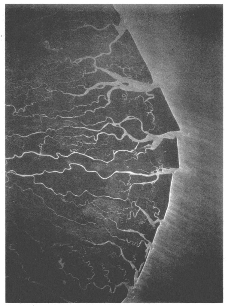
5.The archetypal fan-shaped delta of the Niger River,the largest deltain Africa
River ecology
A great diversity of creatures makes up the ecology of rivers,an interconnected web of life that ranges from microscopic algae to huge fish larger than a human being.Their diverse communities reflect the great array of running water environments that vary from large lowland rivers occupying basins on a subcontinental scale to small,turbulent mountain brooks.The physical structure of the river is one set of influences on its ecology,but chemical and biological attributes are also important,and all are to some degree related.The water's oxygen content,acidity or alkalinity,nutrients,metals,and other constituents are all determined largely by the types of soil and rock that make up the drainage basin,but also in part by interactions with plants and animals both in the water and on land.
The organisms found in fluvial ecosystems are commonly classified according to the methods they use to gather food and feed.‘Shredders’are organisms that consume small sections of leaves;‘grazers’and‘scrapers’consume algae from the surfaces of objects such as stones and large plants;‘collectors’feed on fine organic matter produced by the breakdown of other once-living things;and‘predators’eat other living creatures.The relative importance of these groups of creatures typically changes as one moves from the headwaters of a river to stretches further downstream,
reflecting physical factors such as channel width,shading by trees,and the velocity of the water.This is the‘river continuum concept’which describes a continuum of changes that integrate energy sources,food webs,and stream order in an essentially linear way.Hence,small headwater streams are often shaded by overhanging vegetation which limits sunlight and photosynthesis but contributes organic matter by leaf fall.Shredders and collectors typically dominate in these stretches,but further downstream,where the river is wider and thus receives more sunlight and less leaf fall,the situation is quite different.Here,food chains are typically based on living plant material rather than leaf fall,so there are few shredders and probably more predators.
The river continuum concept is a popular model that has influenced many studies of fluvial ecosystems,but it is not the only one.Another important model used to study river ecology stresses the importance of the annual pulse of floodwaters that extends many rivers in temperate and tropical regions on to their floodplains.The‘flood-pulse concept’broadens the focus beyond the main river channel and puts much greater emphasis on interactions with a greater variety of habitats such as the marshes and lakes typically found on floodplains.These habitats are broadly synonymous with the river's‘riparian’zone(from the Latin word ripa,a bank),made up of any land that adjoins,regularly influences,or is influenced by a body of water.Vegetation in the riparian zone helps to maintain the condition of aquatic ecosystems in several ways.These include providing bank stability and so minimizing erosion,filtering sediment,and processing nutrients from the drainage basin,particularly nitrogen.Fallen branches or trunks from riparian trees also create woody habitat areas for many fish and smaller creatures.
From the ecological perspective,the unidirectional flow of a river is a unique situation.Flowing water influences many aspects of the river environment,moving things and thus helping to disperse organisms and transport nutrients.Flowing water affects the shape of the channel and the nature of its bed,disturbing both on occasions of strong flow,maintaining a dynamic habitat for fluvial plants and animals.Rivers also deliver water,energy,sediment,and organic matter to marine ecosystems.This flow is overwhelmingly in one direction,but not entirely so.Some fish swim against the flow,migrating upstream to spawn,for instance.Fish that migrate from the sea into fresh water for breeding,so-called‘anadromous’species,such as salmon,are prime examples.Salmon attain most of their body mass feeding at sea,so when they die in a river after spawning their carcasses make an important contribution of nutrients and energy to both aquatic and adjacent terrestrial ecosystems.
The flow of water has almost inevitably produced an emphasis on spatial complexity in studies of river ecology,but variations in stream flow over time are also important.The quantity,timing,and variability of a river's flow create a mosaic of habitats to which fluvial organisms have adapted.The ecology of rivers in regions with a Mediterranean climate,for example,is attuned to substantial seasonal variability in flow because most of the rain falls in winter(often 80%or more in three months).A cool,wet season is followed by a warm,dry season which produces a rhythm of flooding and drying in the rivers,although the intensity of each season can vary markedly from year to year.
There's no doubting the numerous fundamental ways in which a river's biology is dependent upon its physical setting,particularly in terms of climate,geology,and topography.Nevertheless,these relationships also work in reverse.The biological components of rivers also act to shape the physical environment,particularly at more local scales.Beavers provide a good illustration of the ways in which the physical structure of rivers can be changed profoundly by large mammals.They cut wood and construct dams,trapping sediments and organic material,modifying nutrient cycles,and ultimately influencing many other communities of plants and animals.
Finally,it is worth emphasizing again the many ways in which the ecology of rivers has effects far beyond the channel itself.In the same way that a river plays a key role in shaping the landscape it moves through,its flow provides important services to many of the plants and animals that inhabit that terrain.The most obvious of these is as a source of water and sustenance.Flowing water both delivers and removes many vital nutrients and other constituents to and from ecosystems,but rivers also have effects that may be less immediately obvious.The distribution of many terrestrial plant and animal species concords with the geography of major river systems because rivers can act both as corridors for species dispersal but also as barriers to the dispersal of organisms.One of the first to recognize the importance of rivers as obstacles to the movement of certain creatures was the naturalist Alfred Russel Wallace,who in the mid-19th century defined distinct areas in South America bounded by major rivers in the Amazon Basin,each with its own distinct communities of species.This idea of the river acting as a barrier is one of a number of hypotheses put forward to explain the evolutionary origin of the astonishing richness of species found in Amazonian forests.
The Amazon:mightiest of them all
By almost every measure,the Amazon is the greatest of all the large rivers.Encompassing more than 7 million square kilometres,its drainage basin is the largest in the world and makes up 5%of the global land surface.The river accounts for nearly one-fifth of all the river water discharged into the oceans.The flow is so great that water from the Amazon can still be identified 125 miles out in the Atlantic:early sailors could drink fresh water from the ocean long before their first sighting of the South American continent.Nonetheless,the lower reaches of the Amazon flow down such a gentle gradient that the physical influence of sea tides can still be identified more than 1,000 kilometres upstream from the Atlantic.
The Amazon has some 1,100 tributaries,and 7 of these are more than 1,600 kilometres long.The main tributaries are often classified according to the colour of their waters,which also reflects their source.Black-water tributaries attain their tea colour from high levels of dissolved plant matter leached from low-lying areas of sandy soils.White-water rivers are coloured by the high loads of sediments transported from the Andes.The clear-water rivers carry low levels of sediments and organic matter from the crystalline rocks of the Guyana and Brazilian shields.
In the lowlands,most Amazonian rivers have extensive floodplains studded with thousands of shallow lakes.Up to one-quarter of the entire Amazon Basin is periodically flooded,and these lakes become progressively connected with each other as the water level rises.Researchers using GPS have measured a sizeable part of South America sinking by nearly 8 centimetres because of the extra weight due to flooding in the Amazon,an area that rises again as the waters recede.This annual rise and fall of the Earth's crust is the largest we have detected.
Many of the Amazon's plants and animals have adapted to living in an environment that is seasonally waterlogged,some areas for up to 11 months a year and to depths of 13 metres.Many tree species of the Amazon rainforest depend on the floods for seed dispersal,for example,either floating downriver or through fish species that are dependent on fruits and seeds.The great diversity of the Amazon's aquatic habitats has played a key role in producing the most diverse fish fauna on the planet.In total,with about 2,500 fish species that have been described by scientists(and probably more than 1,000 still awaiting description),the Amazon's species Fichness comfortably exceeds that of all other large river basins.Its two mightiest fish,the arapaima and the piraiba,each has a maximum weight of about 200 kilograms,more than twice that of an average man.
The one measure by which the Amazon is not generally regarded as the greatest of all rivers is length.It is comfortably the longest in the Americas,but most authorities place the Nile at the top of the world list.However,the difficulties in measuring the length of a river mean that debate on the matter will undoubtedly continue(see above).
The Onyx:an unusual river
The longest river in Antarctica,the River Onyx is just 32 kilometres in length and is in many respects quite different from rivers in most parts of the world.The Onyx is situated in the McMurdo Dry Valleys region,one of a small number of ice-free desert areas that occur along the coastline of an otherwise ice-covered continent.The climate is very dry and bitterly cold,with an average annual temperature of-20℃.The small amount of precipitation(less than 100 millimetres a year)that does fall comes only as dry snow and has virtually no direct effect on the river because fierce winds mean it never settles.Hence,the Onyx,and other rivers of the McMurdo Dry Valleys,flow for only four to ten weeks a year.This occurs during the summer when the temperature is warm enough to melt glacier ice,the only source of river water.
The Onyx flows from the Lower Wright Glacier into Lake Vanda,which has a salinity more than ten times that of seawater and a permanent cover of ice.There are no plants in the region and no fish or insects in the river,but worms,microscopic animals,and communities of algae growing as mats inhabit the river bed.These algal mats can survive long periods of desiccation,making the Onyx a relative hotspot of life in an otherwise barren landscape.
River floods
To hydrologists,the term‘flood’refers to a river's annual peak discharge period,whether the water inundates the surrounding landscape or not.In more common parlance,however,a flood is synonymous with the river overflowing its banks,and this is the meaning used here.Rivers flood in the normal course of events.This often occurs on the floodplain,as the name implies,but flooding can affect almost all of the length of a river.
Extreme weather,particularly heavy or prolonged rainfall,is the most frequent cause of flooding.The melting of snow and ice is another common cause.These events can often be predicted to an extent because they are seasonal.Other reasons for river floods are usually harder to anticipate.They include landslides,log jams,ice jams,avalanches,volcanic eruptions,and earthquakes.
River floods are one of the most common natural hazards affecting human society,frequently causing social disruption,material damage,and loss of life.The hazards associated with floods have encouraged the development of many techniques for predicting them.Flood hazard maps are commonly utilized for land-use zoning,enabling an authority to prohibit certain developments on land that is particularly flood-prone,for instance.
Anticipating when a flood will occur can be done in several different ways.Most floods have a seasonal element in their occurrence and can often be forecast using meteorological observations,with the lag time to peak flow of a particular river in response to a rainstorm calculated using a flood hydrograph.
Other flood predictions seek to estimate the probable discharge which,on average,will be exceeded only once in any particular period,hence the use of such terms as‘50-year flood’and‘100-year flood’.It is a general rule that the magnitude of a flood is inversely related to its frequency,or probability,of occurrence(in other words,the larger the flood,the less likely it is).A flood that is likely to occur only once in a hundred years-the 100-year flood-has a 1%likelihood of occurring in any year,and the average interval between two floods of that magnitude is 100 years.For engineering purposes,it is useful to know the probability of a flood of a particular magnitude so that,for example,a bridge designed to last for 50 years can be built large enough to withstand a 50-year flood,and often a 100-year flood just in case.These are statistical probabilities,however,and there is still the chance that the bridge may be swept away by a far larger flood.
Many of the less predictable causes of flooding occur after a valley has been blocked by a natural dam as a result of a landslide,glacier,or lava flow.Natural dams may cause upstream flooding as the blocked river forms a lake and downstream flooding as a result of failure of the dam.Earthquakes,which can cause enormous landslides,are a particularly common cause of natural dams.For example,the Īnangahua earthquake in South Island,New Zealand,in May 1968 triggered a huge landslide that dammed the Buller River.The rising water backed up for 7 kilometres,raising the river 30 metres above its normal level.Fears that the dam might suffer a catastrophic breach led to an evacuation of all the people living in its path,but the river eventually overflowed the landslide dam,eroding it downward gradually without causing serious flooding downstream.
Breaches of natural dams account for most of the largest known floods of the last 2.6 million years,the so-called Quaternary Period.The biggest that we know about occurred as a result of ice-dam failure after pre-existing continental drainage systems were blocked by ice sheets during the Ice Ages that have characterized the Quaternary.Some of the largest ever to have occurred on Earth were the Missoula floods in the northwestern USA of today.They resulted from the repeated breaching of an ice dam that blocked the present-day Clark Fork River between about 18,000 and 13,000 years ago.The ice created an immense lake known as glacial Lake Missoula which spilled out to create the Missoula floods when the ice dam periodically failed.The peak discharge of the Missoula floods is thought to have been a gigantic 17 million cubic metres per second,more than ten times the combined flow of all the rivers of the world today.
The evidence for the Missoula floods is convincing,but it is one of several great floods known or suspected to have occurred in prehistoric and geological times and not all are as well substantiated.Somewhere at the confluence of fact and fiction lie hundreds of flood legends from cultures all across the world.These stories take their place among a far greater number of myths,sacred traditions,and beliefs based on the flow of rivers that form the subject of the next chapter.