Chapter 3 Liquid histories
Chapter 3 Liquid histories
I have seen the Mississippi.That is muddy water.I have seen the St Lawrence.That is crystal water.But the Thames is liquid history.
John Bums(1858-1943)
(British politician)
Rivers reflect history.They also help to create it.Societies interact with rivers for many reasons,and these motivations can be classified simply into those rooted in the useful aspects of rivers and those that reflect rivers as hazards.People derive many benefits from rivers.We have caught and eaten fish from them for tens of thousands of years.Rivers provide water for domestic,industrial,and agricultural uses.They also provide all sorts of minerals,ranging from gold and diamonds to the sand and gravel that is so essential to modern construction.The energy in a flowing river can be harnessed to facilitate trade and travel,to generate electricity,and to remove many types of waste produced by human activities.People enjoy rivers for recreational and aesthetic reasons,and as havens for wildlife.Conversely,rivers can breed fear and trepidation.This may be a function of quantity:either too much water-a flood;or too little-a water shortage.The quality of river water may.also be a cause for concern,as a bearer of disease or dangerous concentrations of minerals such as arsenic.
All of these facets of rivers as perceived by society have inevitably had some bearing on the course of human history.Much of Europe's story can be told through the story of the Danube.The rivers of Bangladesh compose both the landscape of the nation and the life of its people.London is nothing without the Thames.Rivers are an essential part of the very fabric of many societies and their histories.
The first civilizations
Ancient civilizations emerged on the floodplains of large rivers in several parts of the world between 3,500 and 5,500 years ago.The appearance of the Sumerian,Egyptian,and Harappan civilizations along the alluvial valleys of the Tigris-Euphrates,the Nile,and the Indus respectively was due in large part to the key benefits offered by their rivers:an abundant supply of fresh water,fertile alluvial soils,and a ready transport corridor for trade and travellers.In each case,the society's reliance on its river was emphasized by the arid location,making inhabitants particularly dependent upon a reliable flow of water for agriculture and their continued existence in a desert environment All three river systems are exotic:rising in areas with more humid climates which maintain their perennial flow through the desert.
One theory linking many of the factors involved in the emergence of these first civilizations suggests that the central organization required to manage irrigation in desert areas also allowed complex societies to evolve as large numbers of people congregated to live in the same place.This tendency led eventually to the creation of the first cities and what are popularly thought of as the first civilizations.Each of these three early river-based civilizations developed its own ways of diverting and channelling water,growing and storing food.Systems for writing,making laws,and many other hallmarks of civilization also emerged separately in these three regions.This theory of‘hydraulic civilizations’suggests that the deliberate manipulation and regulation of their rivers by these early societies was an inherent and necessary precondition of civilization.
Another idea takes the links between these early complex societies and their rivers a step further,to suggest that the nature,character,and longevity of the civilization was in part a reflection of the nature of its river.The Tigris-Euphrates,Nile,and Indus are all large,exotic river systems,but in other respects they are quite different.The Nile has a relatively gentle gradient in Egypt and a channel that has experienced only small changes over the last few thousand years,by meander cut-off and a minor shift eastwards.The river usually flooded in a regular and predictable way.The stability and long continuity of the Egyptian civilization may be a reflection of its river's relative stability.The steeper channel of the Indus,by contrast,has experienced major avulsions over great distances on the lower Indus Plain and some very large floods caused by the failure of glacier ice dams in the Himalayan mountains.Likely explanations for the abandonment of many Harappan cities,including Mohenjo Daro,take account of damage caused by major floods and/or the disruption caused by channel avulsion leading to a loss of water supply.
Channel avulsion was also a problem for the Sumerian civilization on the alluvial plain called Mesopotamia-‘the land between two rivers'-known for the rise and fall of its numerous city states.Most of these cities were situated along the Euphrates River,probably because it was more easily controlled for irrigation purposes than the Tigris,which flowed faster and carried much more water.However,the Euphrates was an anastomosing river with multiple channels that diverge and rejoin.Over time,individual branch channels ceased to flow as others formed,and settlements located on these channels inevitably declined and were abandoned as their water supply ran dry,while others expanded as their channels carried greater amounts of water.
Pathways for exploration
The straightforward pathways offered by rivers have always been used by people arriving to explore new lands.Archaeological evidence suggests that early humans penetrated an island later to become known as Britain along its major rivers during the Palaeolithic period or early Stone Age,later spreading out and settling areas further from the river banks.Similarly,some 6,000 years ago,Neolithic tribes used river courses to enter Central Europe from the southeast.In both cases,river valleys offered plentiful supplies of essential resources for these early settlers:water,fish,and floodplains rich in game for hunting.
Many hundreds of years later,the great river systems of North America enabled European pioneers to explore vast new territories,opening them up to trade and eventual colonization.In the 16th century,a succession of French traders,explorers,and missionaries were the first Europeans to arrive in the Great Lakes region,following the exploration of the St Lawrence River by their fellow countryman Jacques Cartier in the 1530s.Dispatched by the king of France,their main purpose was to chart the river systems as highways that allowed access to a new continent.These were often the only thoroughfares through the otherwise impenetrable forests of North America,traversable by canoe as liquid highways or dogsled when many tributaries froze over during the winter.
By 1804,when Meriwether Lewis and William Clark were sent by US president Thomas Jefferson to explore,survey,and document an immense swathe of North America that he'd just bought from the French-the Louisiana Purchase-rivers were still the easiest routes to follow.Lewis and Clark's expedition took them up the Missouri River,across the Rocky Mountains,and down the Columbia River to the Pacific Ocean.Their expedition and the information they brought back,particularly about the Pacific northwest,played a pivotal part in the westward thrust of US expansion.
Movement along rivers played a similar role in the expansion of Russian power and influence over Siberia and the penetration of Africa by Western European powers.The importance of rivers as pathways for colonial exploration is not simply a subject of historical interest.During the colonization of the Americas in the mid-18th century and the imperial expansion into Africa and Asia in the late 19th century,rivers were commonly used as boundaries because they were the first,and frequently the only,features mapped by European explorers.The diplomats in Europe who negotiated the allocation of colonial territories claimed by rival powers knew little of the places they were carving up.Often,their limited knowledge was based solely on maps that showed few details,rivers being the only distinct physical features marked.Today,many international river boundaries remain as legacies of those historical decisions based on poor geographical knowledge because states have been reluctant to alter their territorial boundaries from original delimitation agreements.
Australia's Murray River
The Murray River in the southeast of Australia is of immense cultural,economic,and environmental importance to the continent.Its significance becomes greater still if its two largest tributaries,the Murrumbidgee and Darling Rivers,are included.Altogether,the Murray-Darling Basin drains about 14%of Australia's total land area.Numerous Aboriginal peoples relied on the abundance of the river for thousands of years before the arrival of Europeans,hunting and trading along the Murray in canoes cut and shaped from the bark of gum trees growing on the river's edge.Rock art,archaeological and burial sites remain as evidence of these early inhabitants.Their diet from the river was varied,including fish,crayfish,mussels,frogs,turtles,and waterfowl and their eggs.
It was not until the 1820s that European explorers first saw the river.Captain Charles Sturt navigated down the Murrumbidgee,followed the Murray to discover the Darling confluence,and continued downriver to the mouth of the great river.Publication in London of Sturt's account of his river exploration led indirectly to the establishment of the colony of South Australia.Early European settlers began to penetrate the continent's interior by following the Murray and small settlements and sheep farms started to spring up along its banks.One of the most memorable symbols of the European history of the Murray River is the paddle-steamer,numbers of which ferried wool,wheat,and other goods up and down the river system,helping to open up the Murray-Darling Basin.Irrigated agriculture began in 1887,accelerating settlement and exploitation of the river's water supplies.
Today,the Murray-Darling Basin is Australia's most important agricultural area,producing over one-third of the nation's food supply.It contains 65%of the country's irrigated farmland and supports more than one-quarter of the national cattle herd and nearly half of its sheep.It also provides water to major cities including Canberra and Adelaide.In its natural state,however,the River Murray was a highly variable and unpredictable source of water.During severe droughts,it ceased to be a river at all and was transformed into a chain of salty waterholes,but flow has been regulated for many years to maintain a reliable supply.River regulation on the Murray has been achieved with an array of water engineering structures and techniques.They include five main water storage points,including two large dams-Dartmouth and Hume-and the major managed lakes of Mulwala,Victoria,and Menindee.Since the Hume Dam was completed in 1936,a continuous flow has been maintained throughout the length of the river.The Murray and the Murrumbidgee Rivers also receive additional water supplies diverted through a series of tunnels and pipes from the Snowy River.A system of thirteen weirs and locks further aids flow regulation,and five barrages have been constructed near the river mouth to prevent the intrusion of sea water.Salt occurs naturally in the Murray-Darling Basin in large quantities,and is a water-quality issue for domestic and agricultural use.Hence,a series of salt-interception schemes has been established to keep salt out of the river.These schemes involve large-scale groundwater pumping and drainage projects that intercept flows of saline water and dispose of them by evaporation.
Natural barriers
There are many examples of rivers acting as natural barriers to interaction between groups,and in some cases the separation has continued over periods long enough to be apparent in genetic studies.Among primates in Central Africa,the Congo River forms a clear divide between bonobos,or pygmy chimpanzees,which are found only on the south side of the Congo,and common chimpanzees,which occur only to the north.Chimpanzees are not known to swim,so the river has effectively isolated the two groups,for about 1.3 million years according to genetic analysis,which also confirms that they have a common ancestry.
Similar river barriers to the flow of genes,cultures,and languages have been identified in some human societies.A classic case has been documented by anthropologists in the Highlands of New Guinea where the Lamari River marks a very sharp cultural and linguistic divide between the Fore and the Anga.These two groups speak completely unrelated languages and have markedly different cultures.They are also mortal enemies.Although there maybe several reasons for their differences,the formidable natural barrier presented by the Lamari River and its precipitous valley is certainly an important one,particularly given that the Fore believe people to be incapable of swimming.
Rivers have always demarcated such boundaries,both real and imagined.The River Danube in Europe marked the northern frontier of the Roman Empire in the 1st century AD because it was easily defended,hence also drawing a perceived line between the‘civilized’Empire and the barbarian tribes on the bank opposite.In Europe today,the Danube marks the international border between Slovakia and Hungary,and stretches of Romania's borders with Serbia,Bulgaria,and Ukraine.In southern Germany,the Danube is affectionately known to most Bavarians as the‘Weisswurst equator’(literally,the‘white sausage equator’,named after a favourite food from the south),the symbolic borderline between themselves and the different cultures to the north.
The importance of rivers as natural barriers is reflected in the fact that no less than three-quarters of the world's international boundaries follow rivers for at least part of their course.However,rivers are also notoriously erratic boundaries thanks to their inherent tendency to move,a propensity that can result in a multitude of legal,technical,and managerial challenges for rival states on opposing banks.
These are challenges both in terms of identifying a definitive line in a dynamic natural feature and of managing a divided transboundary water resource.The two elements are of course related:deciding where exactly the boundary runs affects legal rights to the water itself and how it is used(e.g.for navigation)or abused(e.g.by pollution).Often,a river boundary follows the‘thalweg’,the deepest channel in the river,but other principles are also used.Some boundaries follow the median line between the banks,or lines drawn between turning points.Others follow one of the river banks.On occasion,two countries may favour two different legal principles for determining the position of the border,often for opportunistic reasons,and the resulting dispute frequently has to be resolved by international adjudication.Even after the border has been agreed,erosion and sedimentation can alter the banks,the median,or the thalweg,to the benefit of one country and the detriment of the other.
The International Boundary and Water Commission between Mexico and the USA is a long-standing example of the interrelationship between river boundary identification and river management.The commission was created in 1884 to demarcate the border on the ground and to identify its position in the Tijuana,Colorado,and Rio Grande Rivers,but in 1944 it was also given responsibility for allocating the water resources of the Rio Grande.Today,the International Boundary and Water Commission spends most of its time on water management and allocation,rather than on boundary definition.Not all river boundary disputes are settled by peaceful negotiation,however.In 1969,a fierce conflict broke out between the Soviet Union and China lasting several months over their international boundary along the Ussuri River and specifically over the ownership of Chenpao island.
River rights and conflicts
The importance of fresh water as a resource,allied to its uneven geographical distribution in rivers,lakes,and underground aquifers,has inevitably led to political wrangling over the rights of different groups to use water.On occasion,disagreement over rights to shared water resources can lead to militarized confrontation,and the notion that so-called‘water wars’may become a leading source of conflict in the 21st century has become quite widespread in some academic and journalistic circles,as well as in political rhetoric.
Many rivers flow across(as well as along)the borders between nation states,and approximately 60%of the world's fresh water is drawn from rivers shared by more than one country.Some of the world's larger river basins are shared by a great number of countries.The Danube is the greatest of them all in this regard,its basin being shared by no fewer than nineteen countries in Europe.Five other basins-the Congo,Niger,Nile,Rhine,and Zambezi-are shared by between nine and eleven countries.These facts suggest the scale of possible river rights issues,although multiple stake-holders are by no means necessary for political discontent.The River Ganges,for example,flows through just two countries yet was the subject of a twenty-year confrontation between India and Bangladesh following completion of India's Farakka Barrage in 1975.Bangladesh complained that it was being deprived of water it could use for irrigation and was subject to increasing salinity problems thanks to diversions of water by the barrage,sited some 18 kilometres upstream from its border with India.
The dispute over the Ganges,which eventually resulted in the signing of a water-sharing accord in 1996,is not atypical.A downstream state's objection to pollution,the construction of a dam,or excessive irrigation by an upstream state,actions which will decrease or degrade the quality of water available to the downstream state,are all classic grounds for disagreement over a cross-border river.Many of these disputes are peacefully settled by international treaty,but many are not.Further,not all international treaties are designed to address all players in an international river dispute.An example here can be quoted from the Nile.Egypt and Sudan have an international agreement that governs the volume of Nile water allowed to pass through the Aswan High Dam,but none of the other eight Nile Basin countries have agreements over use of the Nile's waters.Given that Egypt and Sudan are the last two states through which the river flows before entering the Mediterranean,similar agreement over water rights with countries further upstream would seem desirable.Hammering out the details of such a treaty has,to date,proved insurmountable,and differences in opinion over rights to Nile water continue to underlie many of the political issues in this part of the world.
Agreements to resolve disputes over water resources have a very long history.The beginnings of international water law can be traced back at least to 2500 BC,when two Sumerian city states-Lagash and Umma-reached an agreement to end a dispute over the water resources of a tributary of the River Tigris in the Middle East.Wrangles over water are still a significant potential source of conflict in the Tigris-Euphrates Basin due to a lack of agreements in the contemporary era.While there is currently a water surplus in this region,the scale of planned developments has raised concerns.The Southeastern Anatolian Project in Turkey,a regional development scheme on the headwaters of the two rivers,envisages the eventual construction of 22 dams.In 1990,when the reservoir behind the Ataturk Dam began to fill,stemming the flow of the Euphrates,immediate alarm was expressed by Syria and Iraq,despite the fact that governments in both countries had been alerted and discharge before the cut-off had been enhanced in compensation.Full development of the Southeastern Anatolian Project,expected by about 2030,could reduce the flow of the Euphrates by as much as 60%,which could severely jeopardize Syrian and Iraqi agriculture downstream.The three Tigris-Euphrates riparians have tried to reach agreements over the water use from these two rivers,and the need for such an agreement is becoming more pressing.(https://www.daowen.com)
Force has been used in conflicts over scarce water resources elsewhere in the Middle East.Attempts to divert water from the Jordan and Yarmuk Rivers led to multiple military incidents between Israel,Syria,and Jordan in the 1950s and 1960s.In 1967,just before the Six-Day War between Israel and its Arab neighbours,then prime minister Levi Eshkol declared that‘water is a question of survival for Israel’,and that Israel would use‘all means necessary to secure that the water continues to flow’.
Since then,the spectre of‘water wars’has assumed greater prominence in popular views of how relations between states sharing a river basin,particularly those in the Middle East,will develop in the future.However,not all authorities see more inter-state conflicts as either inevitable or even the most important aspect of transboundary river management.National economic development is just one dimension of‘water security’,the idea of sustainable access to adequate quantities of water,of acceptable quality,for multiple uses.Such uses also include social and cultural needs but important ecosystem functions too.All of these users should have rights to a river and hence conflicts between them can emerge at levels other than the nation state.
The Mekong Basin illustrates this point.Like many of the world's international river basins,it is simultaneously viewed as an engine of regional economic development,as a crucial basis of livelihood resources,and also as a vital site for the conservation of biodiversity.Critics of the 1995 Mekong Agreement between four of the basin's nation states see the treaty as overly focused on the Mekong's huge hydroelectric potential and capacity to store water for irrigation schemes.Development of this potential is inevitably concentrated at the national level,often with assistance from international development partners such as banks and other governments.These bodies,it is argued,view the Mekong's resources as under-utilized and ripe for development,but the fear is that this stance will marginalize the activities of local resourceusers who depend on the river for sustenance and livelihoods.
Muddy history
The sediments carried in rivers,laid down over many years,represent a record of the changes that have occurred in the drainage basin through the ages.Analysis of these sediments is one way in which physical geographers can interpret the historical development of landscapes.They can study the physical and chemical characteristics of the sediment itself and/or the biological remains they contain,such as pollen or spores.In some places,the sediments may be exposed in a free-face-naturally,such as a cliff,or thanks to human action-and can be examined and sampled fairly easily,but in most cases the sequence of sediments is sampled from the top down,back through time,using a device that drills a core.
The simple rate at which material is deposited by a river can be a good reflection of how conditions have changed in the drainage basin.For example,a study of sediment laid down over a period of 300 years by the Bush River,which flows into Chesapeake Bay on the eastern seaboard of North America,has shown that the amount of soil eroded from the catchment has altered significantly in response to changing land use in the area.Before the settlement of Europeans in the Bush River basin,which began in the mid-17th century,native populations are thought to have had no significant environmental impact on the basin,and the sedimentation rate before 1750 was about 1 millimetre per year.However,the rate was eight times greater by 1820 thanks to early deforestation and agriculture practised by the first Europeans.As the felling of trees progressed and agriculture intensified over the next 100 years,greater erosion followed,and sedimentation rates peaked in 1850 at about 35 millimetres per year.In more recent times,since 1920,urbanization-protecting soils-and the building of dams-blocking the delivery of sediment-have combined to reduce erosion and sedimentation by an order of magnitude.The sedimentation rate has been reduced nearly to the background conditions that prevailed in the pre-European settlement era.
Pollen from surrounding plants is often found in abundance in fluvial sediments,and the analysis of pollen can yield a great deal of information about past conditions in an area.The type of vegetation can be modified by all sorts of factors,including human interference as in the Bush River basin example,but also for entirely natural reasons such as a change in climate or soil conditions.Very long sediment cores taken from lakes and swamps enable us to reconstruct changes in vegetation over very long time periods,in some cases over a million years and more.Because climate is a strong determinant of vegetation,pollen analysis has also proved to be an important method for tracing changes in past climates.
An important study of a 250-metre-long core from the bed of Lake Biwa in Japan,for instance,showed changes in pollen over about the last 430,000 years,a period in which five glacialinterglacial cycles could be recognized.During glacial periods,pollen from pine,birch,and quercus(or white oak)trees was dominant,indicating a climate that was cool and temperate,tending towards subarctic.During interglacial periods,by contrast,high pollen values for species typical of a warmtemperate climate were found,including broad-leaved trees such as the deciduous Lagerstroemia(or Crape myrtle)and the evergreen Castanopsis(a type of beech).
Other evidence for environmental change can be detected in larger-scale elements of the landscape.The floodplains of many modern rivers,for example,bear traces of former channels,so-called‘palaeochannels’,which are different in scale and/or form from the current river.If a palaeochannel is buried beneath more recent sediments,it was probably formed by a river that flowed towards a lower base level,indicating that local sea level or lake level has subsequently changed.River terraces that are found in many river valleys are thought to reflect fluctuations of climate,their formation having been driven by the direct and indirect influence of temperature and precipitation on fluvial activity.
Water power
The energy in flowing and falling water has been harnessed to perform work by turning waterwheels for more than 2,000 years.The moving water turns a large wheel and a shaft connected to the wheel axle transmits the power from the water through a system of gears and cogs to work machinery,such as a millstone to grind corn.An early description of a water-powered mill for grinding grain is given by a Roman engineer named Vitruvius,who compiled a treatise in ten volumes covering all aspects of Roman engineering,and the eastern Mediterranean is strongly associated with the first use of this technology,although a separate tradition of using water power also emerged at about the same time in China.Roman waterwheels were frequently connected to other forms of hydraulic engineering,such as aqueducts and dams,designed to transport river water and control its flow to the wheels.Multiple sets of Roman watermills for grinding grain into flour on a large scale are known from the Krokodilion River near Caesarea Maritima in today's Israel,and from Chemtou and Testour on the River Medjerda(the ancient Bagradas River)in the Roman cornbelt of North Africa,part of Tunisia today.The mills just outside the town of Caesarea Maritima consisted of four vertical waterwheels fed by an aqueduct from a dam on the river.
The power of rivers became widely used in the ancient world for milling grain but also for other purposes.Water-powered mills were also developed to drive trip-hammers for crushing ore and saws for cutting rock.All sorts of water-powered machines became more and more common in medieval Europe,gradually taking over tasks from manual labour.The early medieval watermill was able to do the work of between 30 and 60 people,and by the end of the 10th century in Europe,waterwheels were commonly used in a wide range of industries,including powering forge hammers,oil and silk mills,sugar-cane crushers,ore-crushing mills,breaking up bark in tanning mills,pounding leather,and grinding stones.Nonetheless,most were still used for grinding grains for preparation into various types of food and drink.The Domesday Book,a survey prepared in England in AD 1086,lists 6,082 watermills,although this is probably a conservative estimate because many mills were not recorded in the far north of the country.By 1300,this number had risen to exceed 10,000.
All across Europe,the watermills generally belonged to lords,to city corporations,or to churches or monasteries.Cistercian monasteries were instrumental in the initial development in England of the‘fulling’mill in the late 12th century.Fulling,or felting,was one in a sequence of processes during the production of woollen cloth produced on the monastic estates.It involved scouring and consolidation of the fibres of the fabric,both necessary for proper finishing.The introduction of water-powered technology revolutionized fulling,a process that had hitherto relied on human power to beat the cloth.On the Isle of Wight in southern England,for instance,the first fulling mill was established at the Cistercian monastery of Quarr Abbey on a stream close to large areas of pasture on the abbey's estates.Wool from the flocks of sheep was processed at the abbey and sold in nearby towns.
Medieval watermills typically powered their wheels by using a dam or weir to concentrate the falling water and pond a reserve supply.These modifications to rivers became increasingly common all over Europe,and by the end of the Middle Ages,in the mid-15th century,watermills were in use on a huge number of rivers and streams.The importance of water power continued into the Industrial Revolution,when a series of inventions transformed the manufacture of cotton in England and gave rise to a new mode of production:the factory system.The early textile factories were built to produce cloth using machines driven by waterwheels,so they were often called mills.
The supremacy of running water was soon superseded by steam power generated by burning charcoal,coal,and later oil and gas,although rivers have continued to play a role in industrial power generation.All thermal electric generating stations,whether the source of heat they use is fossil fuels,nuclear,or geothermal,convert water-or some other fluid-into steam to drive electricity-generating turbines.The steam has to be condensed in a cooling system in order to be recycled through the turbines,and large quantities of water are also required for this purpose.Much of this water is drawn from rivers,along with lakes and aquifers and the oceans.
The energy potential of water moving in rivers has re-emerged in the modern era with the advent of hydroelectricity generation.Hydropower is the only renewable resource used on a large scale for electricity generation,and about one-third of all countries rely on hydropower for more than half their electricity.Globally,hydropower provides about 20%of the world's total electricity supply.Most large hydroelectric stations rely on a dam to supply a reliable flow of water to turn their turbines,but small‘run of river’hydroelectric stations do not need such obstacles to the natural flow of the river.Countries with abundant rainfall and mountainous terrain have developed hydropower to become their foremost supply of electricity.Norway is an interesting example.Its rivers provide more than enough hydroelectricity for its own needs so the country has become an exporter of hydropower.

8.Cotton mills on the River Irwell in Manchester,northern England,c.1850,where flowing water in rivers and canals was a crucial component of the Industrial Revolution
Trade and transport
The flow of water in a river has always provided another obvious utility for people:as a conduit for travel,trade,and transport.Many of the world's major cities have developed on navigable rivers thanks to the access they offer,to and from their terrestrial interiors and,in many cases,to territories overseas.The River Thames and London provide a good example.In medieval England,the transportation of goods along the river played an important role in the development of London as a city,and indeed of many other settlements in the Thames valley.Water transport was attractive at this time because of its relatively low cost:moving commodities such as grain and wool by land could be more than ten times the price of transport by water.Cheap transport by river stimulated economic development by increasing the size of markets,encouraging regional specialization,and promoting urbanization.Historical research of transport along the Thames and its tributaries around the year 1300 shows that these waterways greatly extended the market for grain and fuel supplied to the capital.The specialization in farming that developed around London at this time is also likely to have been a result of the increase in transport by river,since some areas were better suited to the production of particular crops than others.Two main impacts on urban development can be identified.For London,development of the cheap fluvial transport network removed a constraint on the city's expansion because it reduced the cost of food and fuel used in the capital.Urban development was also stimulated outside London,in the capital's hinterland,as towns such as Henley-on-Thames grew to become a specialized centre supplying agricultural produce to the city.
Navigable rivers also became major arteries of trade and stimulated the growth of larger settlements elsewhere in medieval England.Gloucester and Bristol were served by the River Severn,York had quays on the River Ouse,and Norwich on the River Wensum.The importance of water transport to urban development was even embodied in the early 12th-century Laws of Edward the Confessor,an Anglo-Saxon king of England.The laws note that navigation should be maintained on the major rivers‘along which ships transport provisions from different places to cities or burghs’.
Many economic historians suggest that England's rivers provided the cheapest form of inland transport for hefty goods right up until the 18th century.Nonetheless,bargemen and merchants wanting to use rivers for trade in the Middle Ages had to struggle constantly against those who wanted to build mills and fish-weirs.The mid-18th century is thought of as the birth of the‘canal age’in England when industrialists built their own waterways,an era that followed a 150-year period in which water transport became progressively easier as many of the country's rivers were‘improved’.
The importance of river transport has played a key role in the economic development of many countries.In Sweden,for example,in the 17th and 18th centuries,logs felled in the country's northern forests were floated down rivers to the mining district of central Sweden where they were used as fuel in smelting operations.During the second half of the 19th century,this form of river transport played an important role in the industrialization of Sweden thanks to the rapid development of an export-oriented forest industry,based on sawmills and later pulp mills.Sweden was able to supply a growing demand for sawn wood and square timber in the industrially developing economies of Western Europe from her forests in the remote northern parts of the country.Timber felling was possible over large areas of northern Sweden thanks to the country's dense network of tributaries and main rivers which generally flow from north to south,enabling cheap long-distance transport of timber to the sawmills and pulp mills on the coast.Sweden's distinctly seasonal climate was also favourable to the transport of timber,since the spring thaw swells rivers with snowmelt that facilitates the floating of logs.At the beginning of the 20th century,sawn timber,pulp,and paper accounted for about half of Sweden's exports by value.The importance of rivers in moving timber within the country only waned in the 1980s when timber-floating operations were abandoned in favour of an expanding road network.River transport of both goods and people continues to be economically important in Bangladesh which,with some 700 rivers and major tributaries criss-crossing the country,has one of the world's largest inland waterway networks.The total length of rivers navigable by modern mechanized vessels shrinks during the dry season,but it still connects almost all the country's major cities,towns,and commercial centres.Indeed,inland ports in Bangladesh handle about 40%of the nation's foreign trade.
Inland water transport is cheaper than road or rail,and is often the only mode that serves the rural poor,proving especially useful during periods of widespread flooding in the monsoon season when many roads become impassable.Country boats,the traditional mode of river transport in Bangladesh for centuries,are also the main means of transport at any time in southern areas of the country where the road network is little developed.
In some parts of the world,trade along rivers has involved contact between radically different cultures,with a range of impacts,some beneficial,others less so.In North America,the fur trade stimulated Euro-American exploration of the Missouri River Valley in the 1700s.Native American Indians met European traders at certain points along the river,some of these trade centres pre-dating contact with Europeans by hundreds of years.American Indians provided beaver pelts and buffalo hides in exchange for manufactured and processed goods such as metal cooking pots,knives,guns,fabrics,beads,coffee,and sugar.By the 1800s,steamboats plied up and down the Missouri River from the town of St Louis where commercial trading companies had established bases.American Indians were exposed to many aspects of Euro-American culture but also,inadvertently,to deadly diseases to which they had no immunity.One epidemic of smallpox in 1837,probably transferred to Plains Indian tribes by a steamboat passenger,killed 10,000 to 20,000 Indians,including over 90%of the Mandan Nation,proprietors of one of the Missouri River's main trading posts.
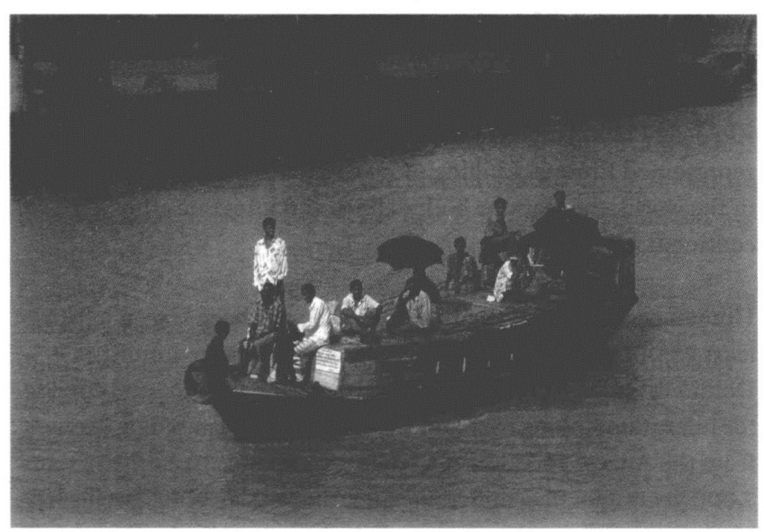
9.Several hundred thousand country boats ply the rivers ofBangladesh,moving passengers and cargo.These boats play a vital role in the lives of rural people and in the rural economy
The Danube:artery of Europe
Although not its longest,many would offer the Danube as Europe's principal river,as it was in the mid-17th century when Pope Innocent X approved construction of the Four Rivers Fountain in Piazza Navona in Rome.Crowned by an Egyptian obelisk,Gian Lorenzo Bernini's most dramatic and spectacular work consists of four marble figures symbolizing the major world rivers known at the time(no doubt in part a reference to the four rivers of Eden).The Nile represented Africa,the Ganges Asia,the Rio de la Plata symbolized the Americas,and the Danube represented Europe.Linking more countries than any other river in the world,the Danube both defines and integrates the continent.
Human occupation of the Danube Valley has been traced back at least 25,000years,when men gathered to hunt mammoth at Dolni Vestonice,in the Czech Republic of today.A natural corridor for migration linking east and west,the river was used by farmers from the Anatolian Peninsula seeking new lands to cultivate some 7,000 years ago.Five millennia later,the Persian King Darius led his vast army along the same route before crossing the Danube in his campaign against the Scythians.The river was established as a corridor for trade by the ancient Greeks and during Roman times,when the Danube was used both as a defensive barrier and as a supply line to feed and equip the legionnaires stationed along it.
Europe's Christian military forces used the Danube as a pathway for heading towards Byzantium and the Holy Land during the times of the Crusades a thousand years ago,and in the 16th century the Danube provided the route for a reverse crusade when Suleiman the Magnificent brought Islam westwards from the Black Sea.In the 1520s,the Ottoman Turks took Belgrade,defeated Hungary,and advanced to the walls of Vienna.They held Budapest for 150 years before being driven back down the Danube.
Trade along the Danube gave rise to two major empires,the Austrian and Hungarian,which merged under the Habsburgs,known to German-speakers as the Donaumonarchie,or‘Danube Monarchy’.Maria Theresa,archduchess of Austria and queen of Hungary and Bohemia,founded an imperial government department to oversee navigation on the river.Today,the‘prince of all European rivers’,as Napoleon Bonaparte liked to call the Danube,flows through four of the continent's capital cities(Vienna,Bratislava,Budapest,and Belgrade)and through,or along the borders of,ten countries.Its role as an important artery for European trade has continued,and navigation along the entire river has been promoted since the first Danubian Commission was set up in the 19th century.The International Commission for the Protection of the Danube River,established in 1998,works to ensure the sustainable and equitable use of freshwater resources in the entire Danube Basin,including the improvement of water quality and the development of mechanisms for flood and accident control.
Given the important role played by this river throughout the history of Europe,its reflection in various aspects of European culture is not unexpected.Before Bernini's Four Rivers Fountain in Rome,the Danube had spawned a school of landscape painting in the 16th century.Some 200 years later,it became the subject of a famous musical waltz by Johann Strauss the Younger.These examples serve to illustrate some of the many ways in which rivers have presented stimulation and inspiration to writers and artists,a subject examined in more detail in the next chapter.