Chapter 5 Tamed rivers
Chapter 5 Tamed rivers
The servitude of rivers is the noblest and most important victory which man has obtained over the licentiousness of nature.
Edward Gibbon(1737-94)
(English historian)
People have interacted with rivers throughout human history and their impacts,both direct and indirect,have taken many forms.The earliest examples of water being extracted from rivers on a significant scale for the irrigation of crops date back 6,000 years.Deliberate manipulation of river channels through engineering works,including dam construction,diversion,channelization,and culverting,also has a long history.Some of the world's oldest dams,in the Middle East,were built more than 4,500 years ago and deliberate diversion and regulation of the Yellow River in China,for example,began more than 2,000 years before the present.Since these early examples,the deliberate human alteration of rivers all over the world has expanded in its extent and escalated in its ambition and scale.Nevertheless,significant geographical differences in the degree and intensity of river modifications remain.In Europe today,almost 80%of the total discharge of the continent's major rivers is affected by measures designed to regulate flow,whether for drinking water supply,hydroelectric power generation,flood control,or any other reason.The proportion in individual countries is higher still.About 90%of rivers in the UK are regulated as a result of these activities,while in the Netherlands this percentage is close to 100.By contrast,some of the largest rivers on other continents,including the Amazon and the Congo,are hardly manipulated at all.
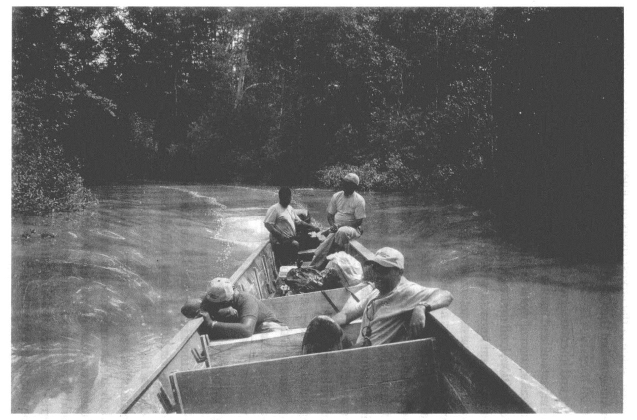
12.Rivers in even the most inaccessible regions are affected to some extent by human activities,as here inthe Darien Gap in Panama,an area renowned globally for its remoteness
Direct and intentional modifications to rivers are complemented by the impacts of land use and land use changes which frequently result in the alteration of rivers as an unintended side effect.Deforestation,afforestation,land drainage,agriculture,and the use of fire have all had significant impacts,with perhaps the most extreme effects produced by construction activity and urbanization.These impacts are diverse and are not all direct.Many aspects of a dynamic river channel and its associated ecosystems are mutually adjusting,so a human activity in a landscape that affects the supply of water or sediment is likely to set off a complex cascade of other alterations.When contemporary climate change is included in the vast array of human activities that in some way result in changes to rivers,many authorities argue that few,if any,rivers-even in the world's least populated regions-remain unaffected by human impact.In many ways,therefore,the evolution and development of rivers is driven as much by social and economic factors as by natural ones.
Irrigated agriculture
One of the most important developments in human society was the shift from a subsistence way of life based on hunting and gathering food from the wild to one primarily based on food production derived from cultivated plants and domesticated animals.The links between early agricultural management and the emergence of urban civilizations in just a few independent centres around the world have beennoted in Chapter 3 along the alluvial valleys of the Tigris-Euphrates,the Nile,and the Indus.These links developed from the high levels of organization needed to manage permanent agricultural fields and systems of irrigation.Another centre of early crop irrigation using river water was in the Zana Valley on the western slopes of the Peruvian Andes,where archeologists have unearthed a system of small-scale gravity canals that were being used at least 5,400 years ago,and probably 6,500 years ago.
Irrigated agriculture is arguably just as important today as it was to those early civilizations,and although several sources of fresh water are used to irrigate cropland-including groundwater,lakes,direct runoff,and various forms of wastewater-rivers remain by far the most important.The methods of storage(in reservoirs)and distribution(by canal)have not changed fundamentally since the earliest river irrigation schemes,with the exception of some contemporary projects'use of pumps to distribute water over greater distances.Nevertheless,many irrigation canals still harness the force of gravity.Half the world's large dams(defined as being 15 metres or higher)were built exclusively or primarily for irrigation,and about one-third of the world's irrigated cropland relies on reservoir water.In several countries,including such populous nations as India and China,more than 50%of arable land is irrigated by river water supplied from dams.
The knock-on effects of withdrawing water from a river to irrigate crops can be striking.In some cases,it may induce a complete transformation of river dimensions,pattern,and shape.One example of such‘river metamorphosis’comes from the western Great Plains of the USA,where rivers described by European Americans towards the end of the 19th century as wide,shallow,braided channels with only sparse vegetation along their banks have since been altered dramatically.The regulation of river flow for irrigated agriculture resulted in lower seasonal peak flows,higher base flows,and a change in regional water tables that promoted the establishment of trees along river banks.The combination of these changes to flow regime and bank resistance resulted in the rivers becoming narrow,sinuous channels flanked by dense forests within just a few decades.
Sadly,many irrigation schemes are not well managed and a number of environmental problems are frequently experienced as a result,both on-site and off-site.In many large networks of irrigation canals,less than half of the water diverted from a river or reservoir actually benefits crops.A lot of water seeps away through unlined canals or evaporates before reaching the fields.Some also runs off the fields or infiltrates through the soil,unused by plants,because farmers apply too much water or at the wrong time.Much of this water seeps back into nearby streams or joins underground aquifers,so can be used again,but the quality of water may deteriorate if it picks up salts,fertilizers,or pesticides.Excessive applications of irrigation water often result in rising water tables beneath fields,causing salinization and waterlogging.These processes reduce crop yields on irrigation schemes all over the world.
Many of these difficulties have plagued farmers in the Central Asian states of Turkmenistan and Uzbekistan where desert conditions mean that more than 90%of agriculture relies on irrigation from the Amu Darya and Syr Darya rivers.A rapid expansion of irrigation in Central Asia was initiated in the 1950s during the Soviet era,with some dramatic consequences.By the 1980s,the irrigated area had more than doubled to occupy about 7 million hectares.As a result,the annual inflow to the Aral Sea from the two rivers,the source of 90%of its water,had declined by an order of magnitude from about 55 cubic kilometres a year to some 5 cubic kilometres annually.
Unsurprisingly,the Aral Sea has become considerably smaller in consequence.In 1960,it was the fourth largest lake in the world,but since that time its surface area has more than halved,it has lost two-thirds of its volume,and its water level has dropped by more than 25 metres.In some areas,the Aral Sea's remaining waters are more than twice as salty as sea water in the open ocean.Most of the lake's native fish and other aquatic species have disappeared,unable to survive in the salt water,meaning an end to a once-major commercial fishing industry.Receding sea levels have also had local effects on climate,and the exposed sea bed has become a source of major dust storms that billow out over surrounding agricultural land up to several hundred kilometres from the Aral's coastline.This fine dust is laden with salts,adding to the problems of irrigated agriculture.It is also thought to have damaging impacts on human health.
Effects on fish
People have directly affected the biology of rivers over a very long period.In Europe,the common carp is found in the rivers of every country,but the fish is native only to the Danube and some of its tributaries.It was introduced to many European rivers by the Romans about 2,000 years ago after large numbers of legionnaires developed a taste for wild carp while stationed along the Danube-then the northern boundary of the Roman Empirein the province of Pannonia.
This was how the common carp became the first species to be introduced into the Seine in France,for instance.It was followed in the Middle Ages by other species,including tench and rudd,which escaped from fish-farming ponds kept by noblemen and religious communities.In the late 19th century,further invaders(nase and pikeperch)arrived in the Seine from rivers further east via canals.These were followed at the end of the century by deliberate introductions of North American species:rainbow trout,black bass,pumpkinseed,and black bullhead.
Native fish began to disappear from the Seine in the 20th century as the construction of weirs and locks made it impossible for migratory species to reach their upstream spawning grounds.With the exception of the eel,all of the Seine's migratory species became extinct:sturgeon,salmon,sea lamprey,sea trout,European smelt,and shad.The original fish fauna of the Seine probably consisted of about 30 species.Today,the river has 46 species,but only 24 of them are native.
The catalogue of human impacts on the fish biology of the Seine is fairly typical of many rivers in the more economically developed parts of the world.Biological invasions generally are widely acknowledged to be one of the major threats to biodiversity across the world in rivers as well as other ecosystems.A study of the global patterns of freshwater fish invasions in more than 1,000 river basins covering more than 80%of the Earth's continental surface identified western and southern Europe as one of six global invasion hotspots,where non-native species represent more than one-quarter of the total number of species per basin.These hotspots also have the highest proportion of threatened fish species.
The human impact was found to be the most important determinant of this situation,particularly the level of economic activity,expressed by the gross domestic product,in a given river basin.The pattern can probably be explained in several ways.Regions that are economically prosperous are more prone to habitat disturbances(e.g.dams and reservoirs modifying river flows)that are known to assist the establishment of non-native species.High rates of economic activity are also likely to increase the chances of invading species arriving via aquaculture,sport fishing,and the ornamental trade.A higher demand for imported products associated with economic development also increases the likelihood of unintentional introductions occurring when imports are made.
Multiple human impacts also contribute to ecological change in rivers in poorer parts of the world,of course.Madagascar,like many islands,has a great many‘endemic’species(those found nowhere else)of all sorts,including fish,and its freshwater species are considered extremely vulnerable.Four of Madagascar's 64 endemic freshwater fish species are feared extinct,and another 38 are endangereddue to three main pressures:habitat degradation caused by deforestation,overfishing,and interactions with exotic species.
Madagascar's widespread deforestation has contributed to the degradation of aquatic habitats in numerous ways.The loss of trees along river banks can result in changes in the species found in the river because fewer trees means a decline in plant matter and insects falling from them,items eaten by some fish.Fewer trees on river banks also results in less shade.More sunlight reaching the river results in warmer water and the enhanced growth of algae.A change in species can occur as fish that feed on falling food are edged out by those able to feed on algae.Deforestation also typically results in more runoff and more soil erosion.This sediment may cover spawning grounds,leading to lower reproduction rates.More sediment can also clog the gills of fish,causing them greater stress which,in combination with other pressures,can lead to their demise.
Overfishing of freshwater species is an intractable problem given the rising demand for fish from a rapidly increasing human population in Madagascar and the great logistical difficulties faced in enforcing any sort of environmental regulations.Exotic fish species introduced to the island include both aquacultural and ornamental species,and their impact on aquatic ecosystems has been profound.Some exotics have become naturalized,completely replacing native fish in the central highlands of Madagascar and becoming widespread in other parts of the island.
River regulation
Efforts to control the water level of rivers and the variability of river flows,to meet the demands of society,date back to the earliest civilizations.Today,rivers are regulated for many reasons,primarily to maintain an even flow for domestic,agricultural,and industrial needs,for hydroelectric power generation,for navigation,and to prevent flooding.The major methods employed in river regulation are the construction of large dams(see below),the building of run-of-river impoundments such as weirs and locks,and by channelization,a term that covers a range of river engineering works including widening,deepening,straightening,and the stabilization of banks.
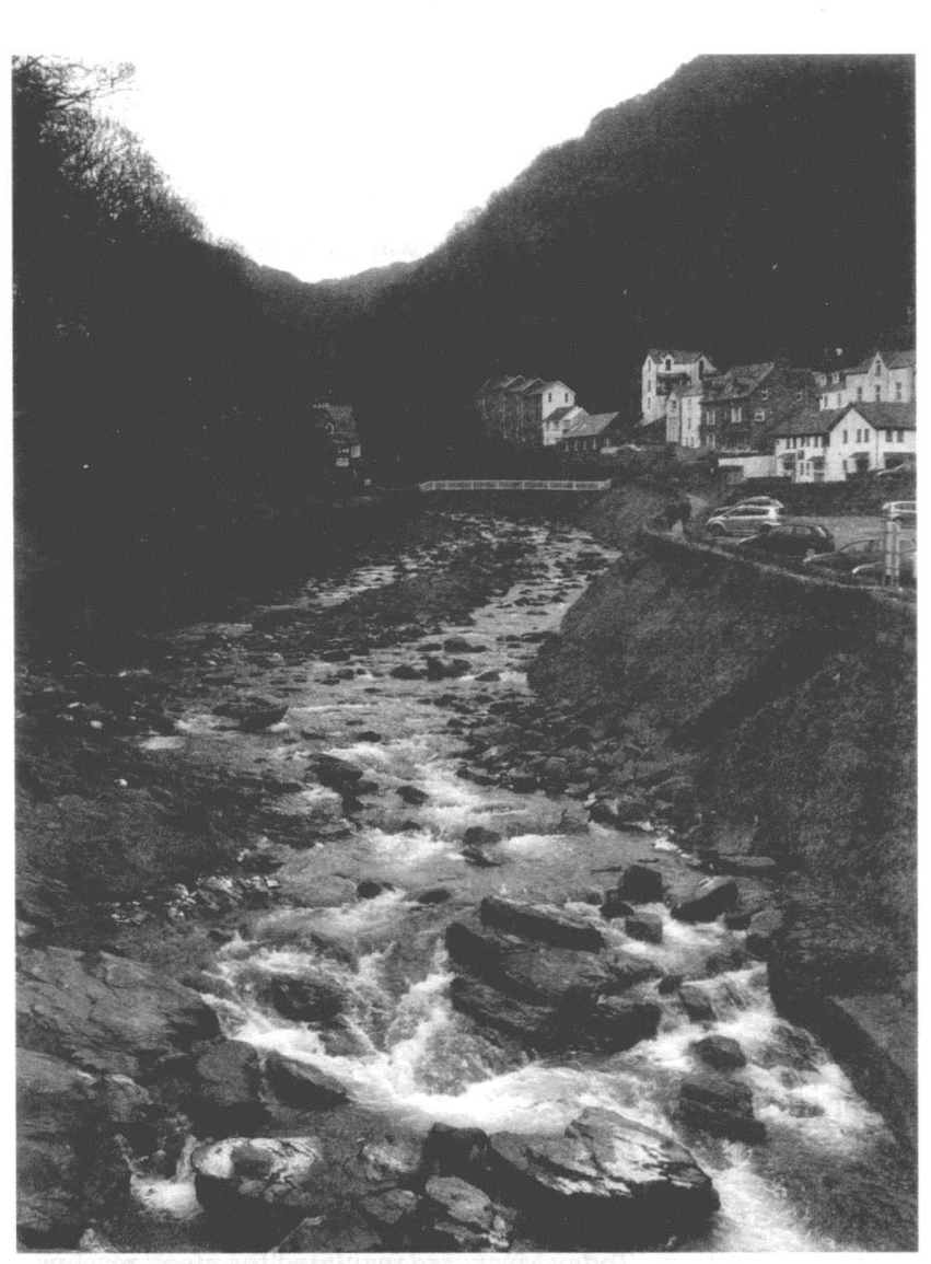
13.The lower reaches of the West Lyn River flowing throughLynmouth in southwestern England were channelized after a devastating flood that killed 34 people in the village in 1952.The channel was widened and embankments built to increase its capacity
Some of the earliest scientific principles of channel regulation were established in Italy,where Leonardo da Vinci is credited with the invention of the pound lock using built-in vertical gates as a means of overcoming variations in river level.He produced the design at the end of the 15th century for a lock on the Naviglio Grande canal from Ticino to Milan,a development that acted as a considerable spur to inland navigation.Two hundred years later,the‘science of waters’was well established in northern Italy with the creation of a chair of‘hydrometry’at the University of Bologna in 1694 and publication of a host of books on river hydraulics.At this time it was advocated that regulation of braided rivers was best achieved by reducing them to a single channel,and by the end of the 19th century most braided rivers in western Europe had been regulated in this way.
Another important phase of river engineering that took place in Europe during the 19th century was the widespread straightening of channels and deepening of beds on major rivers.Significant work of this nature was conducted on the Seine in France and on the Sulina branch of the Danube delta,but one of the most dramatic schemes was implemented on the Tisza River,a tributary of the Danube that flows through Hungary.Regulation of the Tisza,designed to drain land for agriculture and reduce flooding on the Hungarian plain,involved cutting off more than 100 meanders,thus shortening the length of the river by nearly 400 kilometres.
The Yellow:‘China's Sorrow’
One of the most remarkable case histories of river management has unfolded over many centuries along the Yellow River,or Huanghe.It is the world's fourth longest river,although it is only number two in China after the Yangtze,and is also regarded as the world's siltiest,deriving its name from the 1.6 billion tonnes of fine yellow sediment it carries each year as it flows out of the Loess Plateau region and enters the North China Plain.The Yellow River originates on the Tibetan Plateau and flows for more than 5,000 kilometres to the Bohai Sea,an inlet of the North Pacific Ocean.But it hasn't always done so.Like many rivers,the Yellow has changed its course over the years,albeit more frequently than most.In fact,over about the last 2,500 years,the Yellow River has averaged a major change in its course roughly every century.On some occasions,it has not flowed into the Bohai Sea,diverting into the Yellow Sea more than 300 kilometres to the south.For several hundred years,it didn't flow into the sea at all,but into a lake.
Every channel change has meant a major flood disaster on the densely populated plains of eastern China.Indeed,the Yellow's propensity to flood has earned it the nick-name of‘China's Sorrow’.One flood near the sizable city of Kaifeng in September 1642 drowned an estimated 340,000 people,leaving Kaifeng with a population of just 30,000 inhabitants.The Chinese began trying to prevent such floods more than 2,200 years ago by building up the Yellow's river banks with dykes or levées.At the beginning of the 21st century,levées lined the last 870 kilometres of the lower Yellow River to the sea.Constructing levées has probably saved many lives,but the banks have failed in numerous places over the years,still causing inundation on a catastrophic scale.
One of these levée failures,in 1938,was deliberate.During the war against the Japanese,the Chinese Nationalist government ordered its army to dynamite the levée at Huayuankou in an attempt to stop the advance of Japanese forces with an intentional flood.Although several thousand Japanese troops were drowned,the flood only delayed the enemy advance.The brunt of the disaster was borne by the local Chinese population.Eleven cities and more than 4,000 villages were inundated.In total,about 12 million people were affected,nearly 900,000 of them drowning.It was nine years before engineers repaired the levée at Huayuankou and the river resumed its course to the Bohai Sea.
Centuries of levée construction have had other effects.Most rivers in their lower courses deposit mud and silt,and the Yellow is no exception.However,because the river floods only rarely in its lower course,thanks to the levées,most of the material is deposited on the bed of the channel itself.Hence,the river channel has slowly gained height over the centuries,and the levées have had to be raised accordingly.Today,the bed of the lower reaches is on average some 5 metres higher than the land outside its dykes.At Kaifeng,the river bed is 13 metres higher than street level.The residents of Xinxiang go about their business no less than 20 metres below the adjacent Yellow River.The phenomenon is often referred to as a‘hanging river’.
Since the 1960s,a number of large dams and reservoirs have been built in the upper and middle reaches of the Yellow River.They are designed both to help control floods and to supply the 100 million people who rely on the river for their fresh water.The rising demands on the Yellow River's water have created a scarcity,to the extent that in the early 1990s the river failed to reach the sea on certain days.By 1997,there were 226‘no-flow’days,the dry point starting 700 kilometres inland on some occasions.Since then,the Chinese government has ensured for political reasons that the river always reaches the sea,albeit in small volumes.But the river now certainly delivers much less than a billion tonnes of sediment a year to the North Pacific.With so little water actually flowing in the hanging part of the river,the chances of a flood have decreased,but the possibility remains that a major flood further upstream will be too great for the dams to contain and the levées on the lower Yellow will once again be breached,with terrible consequences.
Dams
One of the most profound ways in which people alter rivers is by damming them.Obstructing a river and controlling its flow in this way brings about a raft of changes.A dam traps sediments and nutrients,alters the river's temperature and chemistry,and affects the processes of erosion and deposition by which the river sculpts the landscape.Dams create more uniform flow in rivers,usually by reducing peak flows and increasing minimum flows.Since the natural variability in flow is important for river ecosystems and their biodiversity,when dams even out flows the result is commonly fewer fish of fewer species.
Although dams have been built on rivers for thousands of years,the past 50 years or so has seen a marked escalation in the rate and scale of construction of dams all over the world,thanks to advances in earth-moving and concrete technology.At the beginning of the 21st century,there were about 800,000 dams worldwide,some towering more than 200 metres in height.Certain rivers have been intensively manipulated in this way.North America's River Columbia,for example,has,since the mid-19th century,become the site for no fewer than 80 dams.In some large river systems,the capacity of dams is sufficient to hold more than the entire annual average discharge of the river.The reservoirs behind dams on the Volta River in West Africa can store more than four times the river's annual average flow.Globally,the world's major reservoirs are thought to control about 15%of all runoff from the land.The volume of water trapped worldwide in reservoirs of all sizes is no less than five times the total global annual river flow,and this huge redistribution of water is thought to be responsible for a very small but measurable change in the orbital characteristics of the Earth.
The very first dams were constructed to control floods and to supply water for crop irrigation and domestic use.Modern dams still provide these services,plus a number of others,including hydroelectricity generation and industrial water supply.There is no doubt that many dam schemes have been very successful in achieving their objectives,and in many respects have made substantial contributions to the sustainable use of river resources.In Egypt,the Aswan High Dam has been perceived as a great symbol of economic advancement and national prestige since its completion in 1970.It generates about 20%of the country's electricity,and water held in its reservoir,Lake Nasser,has enabled irrigated agriculture to expand on to 5,000 square kilometres of new land.This is particularly important for a desert country with only a very small area suitable for cultivation.The creation of Lake Nasser has also given rise to a new fishing industry.The dam allows management of the highly seasonal variations in discharge,evening out the Nile's flow to protect against both floods and droughts.The stability of water levels in the river's course has also brought benefits for navigation and tourism.
Despite the success of many dams in achieving their main aims,howewer,their construction and the creation of an associated reservoir bring about significant environmental changes,many of which have proved to be detrimental.The precise nature and magnitude of changes vary greatly with the type of reservoir and the way it is operated,as well as according to the nature ofthe river basin affected.The most obvious impact of a niewdam is the inundation of an area for its reservoir,with associated effects on hydrology,vegetation,wildlife,local climate,and even tectonic processes.
Reservoirs formed by river impoundment typically undergo significant variations in water quality during their first decade or so,before a new ecological balance is reached.Biological production can be high on initial impoundment,due to the release of organically bound elements from flooded vegetation and soils,but declines thereafter.One effect of the nutrient enrichment typical of new reservoirs,particularly in tropical and sub-tropical regions,is the blooming of toxic microscopic algae known as cyanobacteria.These cyanobacterial toxins are dangerous to humans and animals if consumed in sufficient quantities,causing a range of gastrointestinal and allergenic illnesses.Another biological consequence of large reservoirs is the rapid spread of waterweeds that cause hazards to navigation and a number of secondary impacts,notably the loss of water through evapotranspiration.A dramatic example occurred on the Brokopondo reservoir in Surinam during its first two years,where water hyacinth quickly proliferated to cover about half the lake's surface.
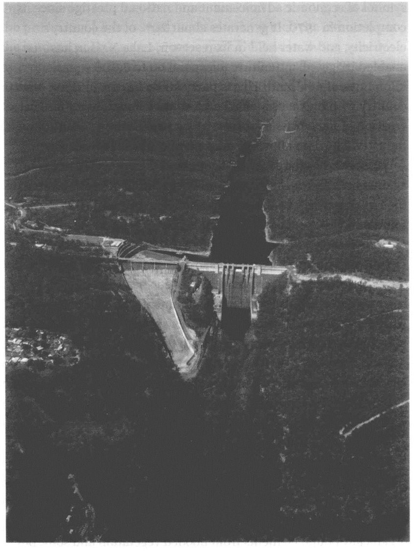
14.The Warragamba Dam near Sydney,Australia,is one of the world'slargest domestic water supply dams.Its reservoir,which is 52 kilometres long,provides 80%of the water for about 4 million people in the Sydney region
Some reservoirs are very large:Brokopondo covers an area of about 1,500 square kilometres,but Lake Volta,the reservoir behind the Akosombo Dam in Ghana,is more than five times as big,making it the world's largest man-made lake.The creation of such vast new bodies of water is thought to affect local climates.Following the establishment of Lake Volta,the peak rainfall season in central Ghana has shifted from October to July/August.Some particularly deep reservoirs can trigger earthquakes due to the stress on crustal rocks induced by huge volumes of water.Nurek Dam on the Vakhish River in central Tajikistan is one of the best-documented examples of a large dam causing seismic activity.This part of Central Asia is tectonically active anyway,but initial filling of the reservoir and each period of substantial increase in water level was mirrored by significant increases in earthquake frequency during the first decade of the dam's lifetime.
The building of a new dam means that any previous inhabitants of the area designated for the reservoir must be moved.The numbers of people involved can be very large and some of the biggest schemes in this respect have been in China.The Sanmen Gorge Project on the Yellow River involved resettling 300,000 people,and the Three Gorges Dam on the Yangtze River has displaced about 1.2 million people from 13 cities,140 towns,and more than 1,000 villages.Governments usually offer compensation to people who are displaced by a new reservoir,but in many remote areas inhabitants do not possess formal ownership documents for the land they live on,a problem that can slow or actually prevent legal compensation.(https://www.daowen.com)
Downstream of a reservoir,the hydrological regime of a river is modified.Discharge,velocity,water quality,and thermal characteristics are all affected,leading to changes in the channel and its landscape,plants,and animals,both on the river itself and in deltas,estuaries,and offshore.By slowing the flow of river water,a dam acts as a trap for sediment and hence reduces loads in the river downstream.As a result,the flow downstream of the dam is highly erosive.A relative lack of silt arriving at a river's delta can result in more coastal erosion and the intrusion of seawater that brings salt into delta ecosystems.Downstream changes in salinity due to construction of the Cahora Bassa Dam in Mozambique threaten mangrove forests at the mouth of the River Zambezi.One knock-on effect of this is a decline in prawns and shrimps,both of which breed in mangroves.
The most dramatic downstream effects have occurred on rivers dammed in several places.Construction of a series of dams in the 20th century on the Colorado River,one of the most intensively used waterways in the USA,has severely cut the river's naturally heavy sediment load,which had led the Spanish explorer Francisco Garces to name it(Rio Colorado is Spanish for‘red-colouredriver’).Before 1930,the river carried more than 100 million tonnes of sediment suspended in its water each year to the delta of the Gulf of California,but it delivered neither sediment nor water to the sea from 1964,when Glen Canyon Dam was completed,to 1981,when Lake Powell behind the dam was filled to capacity for the first time.Since then,river water has reached the Gulf of California only irregularly,when discharges from dams allow.On average,the river now delivers an annual sediment load to the Gulf of California that is three orders of magnitude smaller than the pre-1930 average.The decline in fresh water and nutrients brought by the river to its estuary and the Gulf of California has had a huge impact on ecology.One study suggests that the lack of river-borne nutrients today may have resulted in a 96%decrease in the population of shellfish in the Colorado River Delta in Mexico.
The effects of dams on river ecology are numerous.Other important drivers of ecological impacts include changes in river temperature,the amount of dissolved oxygen carried,and the barrier effect of dams on the dispersal and migration of plants and animals.The dam-barrier effect on migratory fish and their access to spawning grounds has been recognized in Europe since medieval times.A statute introduced in Scotland in 1214 required all dams to be fitted with an opening and all barrier nets to be lifted every Saturday to allow salmon to pass.The problem certainly continues,however,sometimes with considerable economic implications.For example,a dramatic decline in catches of Caspian Sea sturgeon,the source of caviar,during the late 20th century was attributable primarily to the construction of several large hydroelectric dams on the River Volga and the consequent loss of spawning grounds.
Disruption to the movements of fish is one of several reasons for a recent movement in some countries to decommission dams.The small number of dams removed includes those that no longer serve a useful purpose,are too expensive to maintain,or have levels of environmental impact now deemed unacceptable.Most dams that have been removed or considered for removal are on rivers in the USA,but several European countries have also been involved in dam decommissioning.For example,two dams were destroyed and the debris cleared from tributaries of the Loire River in France in 1998 as part of a long-term government management scheme-the Plan Loire Grandeur Nature-for the river and its basin.A central aim of the scheme is to ensure the environmental protection of the Loire and to restore the river's salmon population.Removal of the Maisons Rouges Dam on the River Vienne and the Saint Etienne de Vigan Darn on the River Allier was designed to restore access to salmon spawning grounds.
Land use
Rivers are intimately connected to the landscapes through which they flow,so it should come as no surprise to learn that any changes in a landscape inevitably affect its rivers.The way people use landscapes strongly influences rivers in numerous ways at multiple scales.Clearing natural forest vegetation to provide land for cultivation,for example,is well known to cause less interception of rainfall,less infiltration of water into the soil,less evapotranspiration,and more surface runoff,typically causing enhanced rates of soil erosion,in some cases by several orders of magnitude.Much of that soil finds its way into a river,causing associated changes in channel form and ecology.These types of alteration to rivers have been recorded all over the world,first occurring thousands of years ago in agricultural areas of the Mediterranean and China,and more recently elsewhere.Other forms of food production can also increase runoff and erosion.Grazing and trampling by livestock reduces vegetation cover and causes the compaction of soil,which reduces its infiltration capacity.
As rainwater passes over or through the soil in areas of intensive agriculture,it picks up residues from pesticides and fertilizers and transports them to rivers.In this way,agriculture has become a leading source of river pollution in certain parts of the world.Concentrations of nitrates and phosphates,derived from fertilizers,have risen notably in many rivers in Europe and North America since the 1950s and have led to a range of environmental,social,and economic problems encompassed under the term‘eutrophication’-the raising of biological productivity caused by nutrient enrichment.The growth of algae is the primary concern,leading to human health problems-and hence additional costs of water treatment for drinking-and effects on other river species.In slow-moving rivers,for example,the growth of algae reduces light penetration and depletes the oxygen content of the water,sometimes causing fish kills.
Of course,many of these effects can be controlled by conscious efforts to conserve soil and water on agricultural land.These sorts of measures are undertaken for all sorts of reasons,not least because losing soil and water from fields has an adverse effect on crop yields.Numerous studies undertaken in the Yellow River Basin in China have demonstrated the benefits of soil and water conservation measures,including tree planting and the construction of terraces,introduced in this area primarily to reduce sedimentation in the river's reservoirs.Discontinuing a land use that exacerbates runoff or sediment production is also likely to reduce these effects if the previous vegetation cover is re-established,but this does not always occur.Investigations in the central Andes of Peru found that where agricultural terraces had been abandoned,the rates of soil erosion increased because the environment was too dry for plants to grow on the terraces without attention from farmers.
Another form of land use that has similar effects is mining.In western Siberia,the sediment load of the Kolyma River more than doubled during the 1970s and 1980s due to widespread gold mining in the catchment disturbing vegetation and increasing erosion.Interestingly,records of the Kolyma's discharge over the same period showed no significant trend,indicating that runoff had remained the same.Many mining operations have also caused contamination in rivers.Waste rock and‘tailings’-the impurities left after a mineral is extracted from its ore-typically still contain metals which can be leached into soils and waterways.The accidental release of polluted water from a pond at the Aznalcóllar pyrite mine in southwest Spain in 1998 caused huge damage to birds,fish,and other aquatic species in the Guadiamar River and the Coto Doñana wetland.The water was acidic and contained arsenic,lead,and zinc at concentrations that were lethal for wildlife.Mining has long been associated with impacts on rivers.The Romans developed techniques of hydraulic mining,diverting large volumes of river water to break up and flush away soil and rock and expose minerals.The techniques were widely used to produce gold from alluvial deposits in northwest Spain.
The innumerable links between a river and human activities in its surrounding landscape,and consequently the importance of managing an entire basin,have been recognized for centuries.In Japan,for example,government regulation of timber harvesting along mountain streams in order to maintain channel stability dates back 1,200 years.Similarly,the traditional Hawaiian systems of ahupua'a involved managing drainage basins as an integrated whole to safeguard food production from agriculture and fish ponds.Upland forests were protected by taboo in order to supply rivers with nutrients for downstream fields and fish ponds.In modern parlance,the approach is embodied in‘catchment management plans’which in the countries of the European Union have become mandatory for all major river basins.
The Mississippi
The Mississippi River which,together with the Missouri River,drains two-thirds of the continental USA,has been significantly modified by numerous human activities over the last 200 years or so.A rapid rise in river traffic dating from the beginning of steam boats in the early 1800s spurred the large-scale felling of forests to fire the boats'boilers,and the loss of trees in turn destabilized river banks and contributed to unpredictable migration of the channel.Deforestation and the expansion of commercial agriculture in the Mississippi Basin also resulted in more soil erosion and more sediment reaching the river.Sandbars,a menace to navigation,were one result.As settlements expanded on to low-lying river banks,the Mississippi's floods became a greater danger.
Attempts to manage these problems on the Mississippi in a systematic way began in the 19th century and continue today.Throughout the 1800s,the US Army Corps of Engineers cleared rock and made the channel deeper on particular stretches of the river in an effort to assist navigation.A major programme of river engineering was initiated after a disastrous flood in 1927 in the Lower Mississippi Valley which cost more than 200 lives and displaced over 600,000 people.The Mississippi River and Tributaries Project was designed to control flooding and improve navigation in several ways,and one of these was to straighten the channel by eliminating meanders.Artificially creating a meander cut-off shortens the course of the river,so increasing its gradient and speed of flow.In this way,the water erodes and deepens the channel,thereby increasing its flood capacity.The huge scale of this operation was reflected in a dramatic shortening of the Mississippi.In 1929,a boat sailing between Memphis,Tennessee,and Red River Landing in Louisiana travelled 885 kilometres,but by 1942 the same journey had been shortened by 274 kilometressome 30%-thanks to the series of cut-offs.
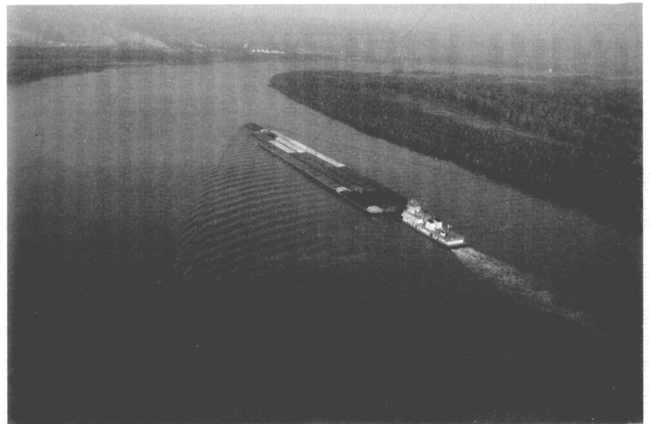
15.Maintaining the Mississippi's role as an importanttransport route has been the motivation for manyhuman impacts on the river.This barge is near Baton Rouge,Louisiana,where the channel is about 700 metres wide
Further protection from floods is provided by nearly 3,500 kilometres of levées and floodwalls along the Mississippi River itself and along some of its major tributaries,but despite these huge efforts the Mississippi is still prone to flooding.The 1993 flood on the river's upper reaches ranks as one of the worst natural disasters in US history,destroying or seriously damaging more than 40,000 buildings.Heavy rain caused the river to breach the levees in more than 1,000 places,and in many locations flooding was prolonged because levées prevented the return of water to the channel once the peak had passed.It also seems very likely that efforts to manage the flood hazard on the Mississippi have contributed to an increased risk of damage from tropical storms on the Gulf of Mexico coast.The levées built along the river have contributed to the loss of coastal wetlands,starving them of sediment and fresh water,thereby reducing their dampening effect on storm surge levels.This probably enhanced the damage from Hurricane Katrina which struck the city of New Orleans in 2005.
Urban rivers
Cities have had numerous impacts on rivers,starting with the rise of the first urban civilizations which emerged on the floodplains of large rivers in several parts of the world a few thousand years ago(see Chapter 3).Archaeological excavations at Harappa and Mohenjo Daro in the Indus Valley have revealed ceramic pipes designed to supply water and brick conduits under the streets for drainage that are thought to have been in operation 5,000 years ago.The Romans are also well known for their sophisticated water-supply systems.Water was brought to Ancient Rome from distant streams and springs via nine major aqueducts.Some of these were more than 60 kilometres in length and involved tunnelling through difficult hillsides with vertical shafts dug for inspection and cleaning.
Large amounts of water were involved in these early municipal systems,but they were ultimately limited in the volume of water managed by the force of gravity.Water could be transferred from one place to another only as long as the direction was down a slope.Modern civilization has hugely increased its ability to move water by using energy to pump water.In the southwestern USA,for example,water from the Colorado River is pumped nearly 500 kilometres across the Mojave Desert to large cities on the west coast of California,including Los Angeles and San Diego.
The growth and development of urban areas-the process of urbanization-is frequently associated with such changes to river systems,some deliberate,others inadvertent.Deliberate manipulation of rivers can be on a significant scale.In Japan,for instance,the city of Tokyo began to develop rapidly after the mid-17th century realization of the Tone River Easterly Diversion Project,a grand scheme that took more than 50 years to complete and involved diverting the Tone River more than 100 kilometres to the east to prevent flooding of the nascent city.The early stages of urban development typically result in a number of other,more subtle effects on rivers.Trees and other vegetation are removed prior to construction which results in less interception of rainfall and less transpiration,both leading to a greater flow of water and more erosion of the bare surfaces,often leading to sedimentation within river channels.In places where scientists have monitored soil erosion from construction sites,the yield of sediment has been up to 100 times greater than under natural conditions.In one extreme case,a rate of more than 600,000 tonnes of soil a year was measured from an abandoned construction site in Kuala Lumpur in Malaysia,about 20,000 times the natural erosion rate.
Other impacts in the early stages of urban development stem from growing numbers of people drawing water directly from a river or drilling wells which can indirectly affect river hydrology by lowering the water table.Rivers also provide a ready source of modern construction materials,and the excavation of sand and gravel can have significant impacts on the geometry and ecology of a river.
One of the most important effects cities have on rivers is the way in which urbanization affects flood runoff.Large areas of cities are typically impermeable,being covered by concrete,stone,tarmac,and bitumen.This tends to increase the amount of runoff produced in urban areas,an effect exacerbated by networks of storm drains and sewers.This water carries relatively little sediment(again,because soil surfaces have been covered by impermeable materials),so when it reaches a river channel it typically causes erosion and widening.Larger and more frequent floods are another outcome of the increase in runoff generated by urban areas.
Contamination of river water has always been an issue in large urban areas,but particularly serious water pollution problems occurred with the growth of cities during the Industrial Revolution thanks to large volumes of domestic sewage and industrial effluents.Water quality in the River Thames at London declined throughout the first half of the 19th century as the city's population grew,along with a rapid increase in the use of the flushing water closet.Untreated sewage flowed directly into the river,along with liquid wastes from a growing number of factories,slaughter houses,tanneries,and other industries located on the Thames.
Organic liquid wastes such as sewage and effluent from industries that process agricultural products can be broken down by bacteria and other micro-organisms in the presence of oxygen.An overload of such organic wastes leads to decreasing levels of dissolved oxygen in a river,so that fish and aquatic plant life suffer and may eventually die.By 1849,fish had disappeared from the tidal Thames,which included the entire length of the river in London.At this time,river water was still being abstracted for public consumption and water-related diseases were rife:five cholera epidemics occurred in London between 1830 and 1871.During the long,dry summer of 1858,the so-called Year of the Great Stink,the Houses of Parliament had to be abandoned on some days because of the terrible stench from the river.
Such a direct impact on the nation's politicians produced some positive action,and conditions in the Thames had improved by the 1890s with the introduction of sewage treatment plants.During the first half of the 20th century,however,sewage treatment and storage did not keep pace with London's growing population,and the oxygen content of the river reached zero 20 kilometres downstream of London Bridge during many summers.Water quality gradually improved after 1950 with tighter controls on effluent and improved treatment facilities.By the 1970s,the river's water was widely regarded as satisfactory,and in 1974 much publicity accompanied the landing of the first salmon caught in the Thames since 1833.
A similar story can be told for rivers flowing through major cities in many parts of the industrialized world:a rapid increase in pollution that accompanies industrialization and population growth leading,in time,to the implementation of pollution controls and recovery to a tolerable environmental quality.Some of the early 21st century's most polluted urban rivers are in the rapidly industrializing parts of Asia.They include the Buriganga River in Dhaka,Bangladesh;the Marilao River in Metro Manila,in the Philippines;the Citarum River near Jakarta,Indonesia;and the Yangtze River which flows through numerous cities in China.
Controlling river blindness
Flooding is the most widespread hazard to human society associated with rivers,but in certain parts of the world a disease named onchocerciasis,or river blindness,is a more enduring concern.The disease is caused by a parasitical worm that is transmitted among humans by the bites of small black flies which breed in rapid-flowing rivers and streams.Once inside the human body,the worms form disfiguring nodules on the skin and their tiny larvae move,causing blindness if they reach the eye.The World Health Organizationestimates that more than 17 million people are infected worldwide,some half a million of whom are visually impaired.
River blindness occurs in parts of tropical Africa,Latin America,and the Arabian peninsula.The presence of the parasite in Latin America is almost certainly a result of infected people moving to the Americas,probably as part of the slave trade.The highest prevalence and the most serious manifestations of the disease still occur in West Africa despite the significant success of a huge programme initiated in the early 1970s to control the disease.The Onchocerciasis Control Programme in West Africa focused on controlling the black fly that transmits the disease by spraying vast stretches of West African rivers with insecticide.At the peak of the programme,this involved more than 50,000 kilometres of river over an area of more than a million square kilometres in 11 countries.Spraying was frequent,almost weekly for 10 to 12 months each year,in some cases over a period of 20 years.The idea was to stop transmission of the parasite for the duration of the life span of the worm in humans,considered to be more than a decade.
This ambitious programme is thought to have protected some 40 million people in West Africa from river blindness and opened up 250,000 square kilometres of land in previously infected river valleys to resettlement and cultivation.Monitoring of other insects,and fish,in the treated rivers indicated few deleterious effects,and the current view of river ecologists is that permanent damage to other creatures in these rivers is unlikely.
Global warming
The human-induced warming of the global climate has issued in a new era of society's influence on rivers.An overall increase in temperature will melt snow and ice and translate into a greater loss of moisture from soils due to higher evaporation and transpiration from plants.River flows will also be affected by changes in precipitation amounts,the intensity and duration of storms,their timing,and the type of precipitation involved.Climatologists agree that extreme weather events(examples include tropical cyclones,droughts,heat waves,and heavy rainstorms)are likely to become more frequent,more widespread,and/or more intense in many parts of the world as the 21st century progresses.All will inevitably result in changes to rivers.Less direct,but potentially no less significant,changes will also occur due to the ways in which plant communities respond to climatic warming.Societies too can be expected to increase their influence on some rivers in response to other aspects of climate change;expanding irrigation systems,for example,in regions subject to more droughts.
Detecting the impact of global warming on rivers is by no means always straightforward because of the difficulties of separating the effect of climate change from the natural variability of many fluvial characteristics and the need to take account of possible alternative causes of change,such as alterations to land use and other human activities.Nonetheless,the influence of global warming has already been identified in some recent modifications to fluvial systems.Work on a number of the world's large drainage basins has established a significant rising trend in the risk of great floods(those with a return period of 100 years)in the 20th century.Warmer air temperatures are also having a predictable effect on glaciers-melting and retreat-in many parts of the world.Glaciers are receding particularly fast in the Himalaya and parts of Tibet,generating worries about long-term water supplies for hundreds of millions of people in India,Bangladesh,Nepal,and China who rely on rivers fed by glacial meltwater.
Ice cover has been in general decline since the mid-19th century on most rivers in North America and Eurasia as gradual warming has meant freeze-up dates have been occurring later and break-up dates arriving earlier.In the case of the lower Don River in Russia,the length of the ice season has been reduced by a whole month in about 100 years.Records for the Tornionjoki River in Finland stretch back to 1692 and show a long-term trend towards earlier break-up dates throughout the entire period.This tendency is not universal,however.Rivers in central and eastern Siberia display significant trends in the opposite direction:towards longer periods with ice cover due to earlier freeze-up dates and later break-up dates.
Northern hemisphere rivers that flow into the Arctic Ocean have been delivering more water in line with longer ice-free periods,combined with an increase in precipitation.More fresh water in the Arctic could slow down or shut off the so-called‘thermohaline circulation,an oceanic current conveyor belt which transports large amounts of warm water to the North Atlantic region.This circulation is driven by differences in the density of sea water,controlled by temperature and salinity,so more fresh water could counteract the flow.The thermohaline circulation helps to regulate the climate of northern Europe,maintaining temperatures that are higher than would be otherwise expected given the latitude.
Conversely,a number of other rivers have seen declines in the amount of water they carry each year since the mid-20th century.Several of the major rivers with dwindling flows serve large populations,sparking further concerns about future water supplies.These rivers include the Yellow River in northern China,the Ganges in India,the Niger in West Africa,and the Colorado in North America.
Drought is thought to be the greatest agent of change associated with global warming in the Amazon Basin.Many computer-based models of future climate in the region indicate a reduction of dry-season rainfall,the effects of which will be exacerbated by rising air temperatures.This increased probability of drought will have all sorts of knock-on effects for the forest ecosystems and the rivers running through them,including a greater likelihood of fire.The consequences for local people,wildlife,and the rivers themselves are expected to be serious.
In Europe,the discharge of the Rhine is expected to become more seasonal because of global warming.Estimates generated by computer models indicate that by 2050,the average flow in summer will decrease by up to 45%and the average winter flow will increase by up to 30%.Less water in the Rhine during the summer months is related mainly to predicted decreases in precipitation and increases in evapotranspiration.Greater flows in winter will be caused by a combination of more precipitation,less snow storage,and increased early melting.The hazards posed by winter floods on the Rhine will certainly increase in consequence.Greater seasonality in the river's flow will also have numerous repercussions for the ecology of the Rhine.
River restoration
The numerous ways in which human activities have influenced rivers,both purposefully and indirectly,are complemented in many countries by efforts to reverse some of the earlier effects of human action:so-called‘river restoration’.Attempts to improve conditions in rivers are not new in themselves,as evidenced in the clean-up of the Thames in London cited earlier in this chapter,for instance,but the widespread adoption of restoration,rehabilitation,and mitigation measures has been recognized as a distinctive phase of river management in the late 20th and early 21st centuries.Restoration projects usually involve efforts to repair damage to rivers,typically in an attempt to better meet societies'needs and expectations for natural,ecologically healthy waterways.
Returning a river to its‘natural’or‘original’condition is usually fraught with difficulty,however.Theoretically,at least,this can be based on an understanding of historical conditions along a river before human effects,or on conditions along a similar but less affected reference river.In practice,however,an appropriate reference river may not exist,or conditions in a basin(such as climate or vegetation)may have changed since the period selected for the historical baseline.Indeed,rivers change under all sorts of natural circumstances,and determining which changes are natural and which are due to human pressures is not always straightforward.Further,although it may be possible to determine which human impacts are undesirable,preventing them entirely may be more complicated.
These and other constraints mean that re-establishing conditions that might have existed prior to human settlement of the landscape is virtually impossible.It is more appropriate to restore rivers that are self-sustaining and integrated into the surrounding landscape and are,therefore,generally closer to a more natural state.Hence,for example,the Plan Loire Grandeur Nature for the Loire River in France,one of the largest river restoration programmes undertaken anywhere,aims to ensure the conservation of typical Loire Valley ecosystems(including peatlands,gorges,alluvial forests,and oxbow lakes)on model sites and to maintain their ecological functions.Part and parcel of this effort is the re-establishment of iconic river species such as the beaver and salmon.
Even when the objectives of river restoration programmes are clear,in most cases they will still have to be balanced against other demands put on rivers.Some of these demands may be conflicting.For example,some conservationists argue that river regulation and environmental conservation are intrinsically incompatible since regulation modifies the natural environment in which original wildlife communities became established.Indeed,in certain cases,the ecological requirements of organisms are destroyed or modified beyond the limits of adaptations and the organisms are unable to survive.River management is no different from any other natural environmental management issue in that it involves compromises,and in a world where the growth of populations and economies appears to be inexorable,not to mention the all-embracing effects of human-induced climate change,these compromises are likely to become more and more delicate.