4.4.1 Monitoring of Embankment Deformation
The monitoring work in the construction process can accurately predict and predict the deformation effect.The monitoring data are compared with the predicted value to determine whether the early construction technology and construction parameters meet the expected requirements,so as to determine and optimize the next construction parameters,and do a good job in information construction.The results of surface subsidence analysis and research are applied to the information feedback to optimize the design,and the relationship between stratum characteristics,groundwater conditions and ground subsidence is studied.As the basis for improving the design,the design is more quality,safe,economic and reasonable,and the construction is more rapid.Real-time monitoring can understand the interaction force between stratum and tunnel structure and provide basis for establishing and adjusting shield construction parameters,such as determining shield tunneling speed,controlling stratum disturbance,reducing deformation,ensuring the safety of structure itself and surrounding environment during construction,and accumulating experience and providing guidance for similar projects in the future.
At present,there are many techniques for monitoring modern shield tunneling engineering,which can be divided into two types:deformation monitoring and nondestructive monitoring.Among them,the deformation monitoring has the characteristics of relatively lining installation tube and absolute deformation,and nondestructive supervision.The test can not be used to set up destructive signs,and can be used in monitoring work where the work space is narrow and the monitoring personnel have limited time.As far as the actual situation is concerned,the deformation monitoring technology has been more widely used.
1)Principles for the development of monitoring plans
In the development of monitoring projects,certain principles should be followed in order to ensure the effectiveness of monitoring.First of all,following the reliability principle to develop the monitoring plan,that is,to ensure the reliability of the monitoring program,you need to use reliable instruments and protect the measuring points during the monitoring.Secondly,it is necessary to follow the principle of hierarchy:Specifically,displacement is the main monitoring object,and other monitoring items are taken into consideration;at the same time,instrument monitoring is the main method,and the inspection method is used for coordination;when monitoring instrument selection is made,It is necessary to use machine-based instruments as the mainstay,supplemented by electric measuring instruments.In addition,separate points should be placed on the surface and underground pipelines in order to make the monitoring network have a certain measuring point coverage.It is also necessary to follow the principle of key monitoring of key areas:Specifically,for different geological conditions and different stability standards,it is important to monitor the areas with poor stability.In addition,the principle of convenient use should be followed:In order to prevent the monitoring work from interfering with the construction,the monitoring plan should be made more practical and convenient.Finally,in order to reduce the cost of monitoring,it is necessary to select practical instruments without the need to pursue advanced instrumentation.
2)Selection of monitoring sections
In the selection of monitoring section,geological conditions,engineering requirements and construction conditions should be comprehensively considered.In the layout of the monitoring section,it is necessary to consider the spatial-temporal relationship and adopt the combination of focus and general,local and overall,so as to systematically control the key parts of the project.At present,the monitoring section can be divided into main monitoring section and auxiliary monitoring section.Among them,the main section can be embedded with various instruments in order to monitor various monitoring projects.
3)Arrangement of monitoring points
In the arrangement of monitoring points,the type and number of monitoring points should be determined first according to the engineering properties,geological conditions and construction requirements.On this basis,the design data of monitoring points should be verified in the most unfavorable position and section in the design.At the same time,for the measuring points set to guide the construction,it is necessary to place the measuring points in the first construction site under the same working conditions for testing.Secondly,when determining the position of the surface deformation point,it is necessary to enable the measuring point to reflect the deformation characteristics of the monitored object well,and this position is conducive to the use of instruments and the protection of measuring points.The arrangement of measuring points cannot affect the normal force of stratum structure,nor can it weaken the structural deformation stiffness and strength.In addition,the arrangement of various monitoring points should be organically combined in time and space in order to reflect the change relations and laws of different physical quantities.(https://www.daowen.com)
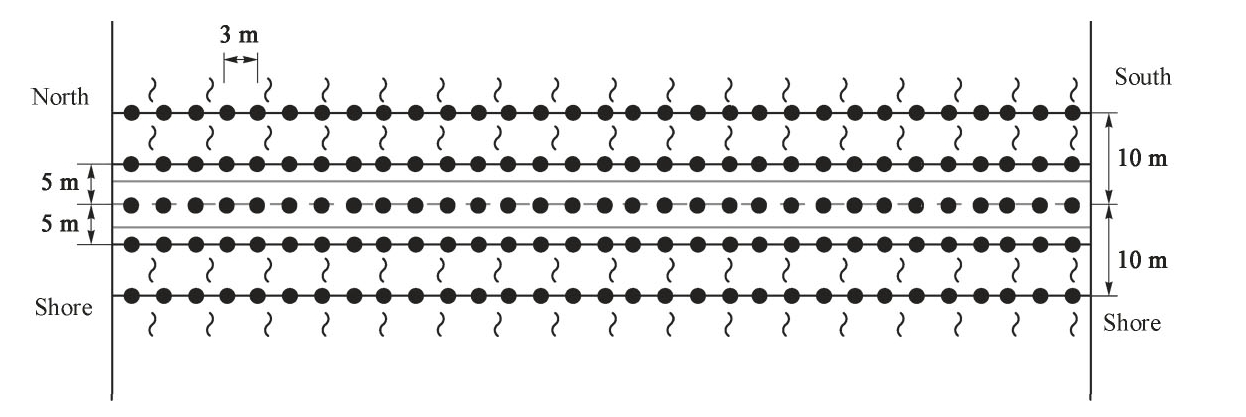
Fig.4.25 Schematic diagram of sonar monitoring point layout
4)Nanjing Yangtze River Tunnel Monitoring Example
The Nanjing Yangtze River Tunnel Project needs to cross the Yangtze River,and the shield adopts sonar and pressure sensor methods when crossing under the Yangtze River.The two methods simultaneously monitor the settlement of the river bottom when the shield passes over the Yangtze River.
(1)Sonar method,mainly through the use of ultrasonic velocity method to measure the depth of water,automated mapping,drawing flat water depth map and section.The method of measuring point is as follows:along the direction of the tunnel axis in the tunnel's central axis line is laid a central axis line,and then the left and right sides each 5 m apart a measuring line,a total of 4 parallel lines parallel to the central axis;shown in Fig.4.25.
(2)The pressure sensor method,mainly by measuring the change of water pressure at the bottom of the river to reflect the size of the river bottom subsidence.The method of measuring point is:along the tunnel line every 10 m arrangement of a sensor point,and the use of a special signal receiver can automatically realtime access to the underwater pressure of each measuring point,by setting the water level benchmark to correct the impact of the tide rise and fall,and finally converted to each point of the elevation,as the basic parameters of data processing,At the same time,the corresponding software is developed for graphical processing,so that the water pressure and subsidence of each measuring point under water can be visually described.
Before the shield reaches the bank of the Yangtze River,a sensor monitoring point is placed every 10 m along the axis of the tunnel,about 54 in total;and a background measurement is performed by the sonar method before the shield crosses the river to understand the topography of the river bottom,as shown in Fig.4.26 is shown.Simultaneous monitoring of river bottom settlement is carried out by sonar method and pressure sensor method.The monitoring frequency of the sonar method is once a day,and the monitoring frequency of the pressure sensor method is twice a day.
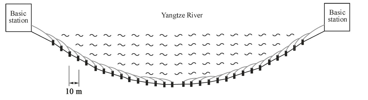
Fig.4.26 Schematic diagram of the monitoring of the pressure sensor method