参考文献
1 Ahmed K.,Bernd H..Elliptic grid generation using NURBS surfaces.Computer Aided Geometric Design,1996.13(4):369-386
2 Apel M..From 3d geomodeling systems towards 3d geoscience information systems:data model,query functionality,and data management.http://www.geo.tu-freiberg.de/~apelm/pub/apel_ cg_03-178.pdf,2005
3 Apprato D.,Gout Ch.,Komatitsch D..A new method for Ck-surface approximation from a set of curves,with application to ship track data in the Marianas trench.Mathematical Geology,2002.34(7):831-843
4 Arakawa K.,Krotkov E..Fractal modeling of natural terrain:analysis and surface reconstruction with range data.Graphical Models and Image Processing,1996.58(5):413-436
5 Arens C.,Stoter J.,van Oosterom P..Modelling 3D spatial objects in a geo-DBMS using a 3D primitive.Computers&Geosciences,2005.31(2):165-177
6 Babaie H.A.,Babaei A..Modeling geological objects with the XML Schema.Computers&Geosciences,2005.31(9):1135-1150
7 Banks P.B.,Sukkar J.K..Computer processing of multiple 3D fault blocks containing multiple surfaces.Geobyte,1992.7(4):58-62
8 Basso K.,Freitas C.M.D.S..Visualization of geological prospecting data.In:International Symposium on Computer Graphics,Image Processing,and Vision Proceedings.Rio de Janeiro,Brazil,1998:142-149
9 Blinn J.F..Simulation of wrinkled surfaces.In:Proceedings of the 5thAnnual Conference on Computer Graphics and Interactive Techniques.New York:ACM Press,1978:286-292
10 Brandel S.,Schneider S.,Perrin M.,et al.Automatic building of structured geological models.Journal of Computing and Information Science in Engineering,ASME,2005.5(2):138-148
11 Breunig M..An approach to the integration of spatial data and systems for a 3D geo-information system.Computers&Geosciences,1999.25(1):39-48
12 Cardozo N..Trishear modeling of fold bedding data along a topographic profile.Journal of Structural Geology,2005.27(3):495-502
13 Caumon G.,Lepage F.,Sword C.H..Building and Editing a Sealed Geological Model.Mathematical Geology,2004.36(4):405-424
14 Caumon G.,Lévy B.,CastaniéL.,et al.Visualization of grids conforming to geological structures:a topological approach.Computers&Geosciences,2005.31(6):671-680
15 Caumon G.,Sword C.H.,Mallet J.L..Constrained modifications of non-manifold b-reps.In:Proceedings of the Eighth ACM Symposium on Solid Modeling and Applications.New York:ACM Press,2003:310-315
16 Caumon G.,Sword C.H.,Mallet J.L..Interactive Editing of Sealed Geological 3D Models.2002 Annual Conference of the IAMG,75-80
17 Cheney D.W..Implications of Information Technologies in Geo-and Bio-Sciences:A Literature Review.http://www.sri.com/policy/csted/reports/sandt/it/IT_Geo_Bio_Lit_Review_Report_final.pdf,2003
18 Courrioux,G.,Nullans,S.,Guillen,A.,et al.3D volumetric modelling of Cadomian terranes(Northern Brittany,France):an automatic method using Voronoïdiagrams.Tectonophysics,2001,331(1-2):181-196
19 Davis J.C..Statistics and Data Analysis in Geology.2ndEdition.New York:John Wiley&Sons,1986
20 De Floriani L.,Magillo P..Visibility algorithms on triangulated digital terrain models.International Journal of Geographical Information Systems,1994.8(1):13-41
21 De Kemp E.A..Visualization of complex geological structures using 3D Bézier construction tools.Computers&Geosciences,1999.25(5):581-597
22 De Kemp E.A..Three-Dimensional Integration and Visualization of Structural Field Data:Tools for Regional Subsurface Mapping Ph.D.Dissertation.Quebec:University of Quebec,2000
23 De Kemp E.A..3D visualization of structural field data:examples from the Archean Caopatina Formation,Abitibi greenstone belt,Quebec,Canada.Computers& Geosciences,2000.26(5):509-530
24 De Kemp E.A.,Sprague K.B..Interpretive tools for 3D structural geological modelling Part I:Bézier-based curves,ribbons and grip frames.GeoInformatica,2003.7(1):55-71
25 De La Losa A.,Cervelle B..3D topological modeling and visualisation for 3D GIS.Computers&Graphics,1999.23(4):469-478
26 De Paor D.G..Bézier curves and geological design.In:De Paor,D.G.(Ed.),Structural Geology and Personal Computers.Oxford:Pergamon Press,1996:389-417
27 Dercole F..Remarks on the computation of the horizon of a digital terrain.Applied Mathematics and Computation,2003.146 (2-3):627641
28 Dimasa E.,Briassoulisb D..3D geometric modelling based on NURBS:a review.Advances in Engineering Software,1999.30(9-11):741-751
29 Dorninger P.,Jansa J.,Briese Ch..Visualization and topographical analysis of the Mars surface.Planetary and Space Science,2004.52(1-3):249-257
30 Egan S.S.,Kane S.,Buddin T.S.,et al.Computer modeling and visualisation of the structural deformation caused by movement along geological faults.Computers&Geosciences,1999.25(3):283-297
31 Euler N.,Sword C.H.,Dulac J.C..A new tool to seal a 3D earth model:a cut with constraints.In:Proceedings of the 68thAnnual Meeting:Society of Exploration Geophysicists.New Orleans,1998:710-713
32 Euler N.,Sword C.H.,Dulac J.C..Editing and rapidly updating a 3D earth model.In:Proceedings of the 69thAnnual Meeting:Society of Exploration Geophysicists.Tulsa,1999:950-953
33 Fang T.P.,Piegl L..Delaunay triangulation in three dimensions.IEEE Computer Graphics and Applications,1995.15(5):62-69
34 Farin G..Curves and Surfaces for Computer Aided Geometric Design.4thEdition.San Diego:Academic Press,1997
35 Ferníández O..Obtaining a best fitting plane through 3D georeferenced data.Journal of Structural Geology,2005.27(5):855-858
36 Fisher T.R.,Wales R.Q..3D solid modeling of sandstone reservoirs using NURBS:a case study of Noonen Ranch field.Denver basin,Colorado.Geobyte,1990.5(1):39-41
37 Fisher T.R,Wales R.Q..Three dimensional solid modeling of geo-objects using non-uniform rational B-splines(NURBS).In:Turner,A.K.(Ed.),Three-Dimensional Modeling with Geoscientific Information Systems.Dordrecht:Kluwer Academic Publishers,1992:85-105
38 Galera C.,Bennis C.,Moretti I.,et al.Construction of coherent 3D geological blocks.Computers&Geosciences,2003.29(8):971-984
39 Ghosh J.K.,Bhanja J.,Purkayastha S.,et al.A statistical approach to Geological mapping.Mathematical Geology,2002.34(5):505-528
40 Guillen A.Meunier,Ch.,Renaud,X.,et al.New Internet tools to manage geological and geophysical data.Computers&Geosciences,2001,27(5):563-575
41 Halbwachs Y.,Courrioux G.,Renaud X.,et al.Topological and geometric characterization of fault networks using 3-dimensional generalized maps.Mathematical Geology,1996.28(5):625~656
42 Harding C..Multi-sensory investigation of geoscientific data:Adding touch and sound to Three-Dimensional Visualization and Modeling.Ph.D.Dissertation.Houston:University of Houston,2001
43 Horsman J.,Bethel W..Methods of constructing a 3D geological model from scatter data.In:Proceedings of AVS 95,1995
44 Houlding S.W..The application of new 3D computer modeling techniques to mining.In:Turner,A.K.(Ed.),Three-Dimensional Modeling with Geoscientific Information Systems.Dordrecht:Kluwer Academic Publishers,1992:303-325
45 Houlding S.W..3D Geoscience Modeling:Computer Techniques for Geological characterization.Berlin:Springer-Verlag,1994
46 Houlding S.W..The application of new 3D computer modeling techniques to mining.In:Turner,A.K.(Ed.),Three-Dimensional Modeling with Geoscientific Information Systems.Dordrecht:Kluwer Academic Publishers,1992:303-325
47 Husson L.,Mugnier J.L..Three-dimensional horizon reconstruction from outcrop structural data,restoration,and strain field of the Baisahi anticline,Western Nepal.Journal of Structural Geology,2003.25(1):79-90
48 Jessell M..Three-dimensional geological modelling of potential-field data.Computers&Geosciences,2001.27(4):455-465
49 Jones,T.A..Modeling geology in three dimension.Geobyte,1988.3(1):14-20
50 Kennie T.J.M.,Mc Laren R.A..Modeling for digital terrain and landscape visualization.Photogrammetric Record,1988.12(72):711-745
51 Kidnera D.B.,Smith D.H..Advances in the data compression of digital elevation models.Computers&Geosciences,2003.29(8):985-1002
52 Kreuseler M..Visualization of geographically related multidimensional data in virtual 3D scenes.Computers&Geosciences,2000.26(1):101-108
53 Kushnir G.,Yarus J.M..Modeling anisotropy in computing of geologic data.In:Hamilton,E.,Jones T.A.(Eds.),Computer Modeling of Geologic Surfaces and Volumes,AAPG Computer Application in Geology 1,Tulsa.The American Association of Petroleum Geologists,1992:75-91
54 Kübler S.,Voisard A..Geo Hyp:an adaptive human interface for geologic maps and their databases.ISPRS Journal of Photogrammetry&Remote Sensing,1999.54:234-243
55 Lecour M.,Thore P.,Dulac J.C..Modeling faults taking uncertainties into account.http://gocad.org/IMG/papers/1998/1998.seg.lecour.pdf,1998
56 Lemon A.M.,Jones N.L..Building solid models from boreholes and user-defined cross-sections.Computers&Geosciences,2003.29(5):547-555
57 Lin C.R.,Loftin R.B.,Nelson H.R..Interaction with geoscience data in an immersive environment.In:Proceedings of Virtual Reality 2000.Washington:IEEE Computer Society,2000:55-62
58 Lin C.R,Loftin R.B.,Stark T..Virtual Reality for Geosciences Visualization.In:Proceedings of the Third Asian Pacific Computer and Human Interaction.Washington:IEEE Computer Society,1998:196-201
59 Liu D.A.,Zhang J.M.,Wang S.J..Constrained fitting of faulted bedding planes for three-dimensional geological modeling.Advances in Engineering Software,2002.33(11-12):817-824
60 Longley P.A.,Goodchild M.F.,Maguire D.J.,et al.Geographical Information Systems.Volume 1.Principles and Technical Issues.Second Edition.New York:John Wiley&Sons,1999
61 Lu J..Systematic identification of polyhedral rock blocks with arbitrary joints and faults.Computers and Geotechnics,2002.29(1):49-72
62 Mallet J.L..Discrete smooth interpolation in geometric modeling.Computer Aided Design,1992.24(4):178-190
63 Mallet J.L..Discrete modeling for nature objects.Mathematical Geology,1997.29(2):199-218
64 Mallet J.L..Geomodeling.New York:Oxford University Press,2002
65 Marschallinger R..CAD-based 3D modeling in geosciences:application of the NURBS concept.In:Proc.Int.Assoc.Mathem.Geol.meeting.Prague,1995:1-5
66 Marschallinger R..A method for three-dimensional reconstruction of macroscopic features in geological materials.Computers&Geosciences,1998.24(9):875-883
67 Marschallinger R..Three-dimensional reconstruction and visualization of geological materials with IDL—examples and source code.Computers&Geosciences,2001.27(4):419-426
68 Meentemeyer R.K.,Moody A..Automated mapping of conformity between topographic and geological surfaces.Computers&Geosciences,2000.26(7):815-829
69 Moorea R.R.,Johnson S.E..Three-dimensional reconstruction and modelling of complexly folded surfaces using Mathematica.Computers&Geosciences,2001.27(4):401-418
70 Neumann D.,Schönberg G..Strobel G..Three-dimensional modeling of ground conditions for the engineering geological map of the City of Magdeburg.Geotechnik,2005.28(2):101-105
71 Pflug R.,Harbangh J.W..Computer Graphics in Geology:Three-dimensional Computer Graphics in Modeling Geologic Structures and Simulating Geologic Processes.Berlin:Springer-Verlag,1992
72 Piegl L.,Tiller W..Algorithm for approximate NURBS skinning.Computer-Aided Design,1996.28(9):699-706
73 Piegl L.,Tiller W..The NURBS Book.2ndEdition.New York:Springer,1997
74 Pinto V.,Font X.,Salgot M.,et al.Using 3D structures and their virtual representation as a tool for restoring opencast mines and quarries.Engineering Geology,2002.63(1-2):121-129
75 Raghothama S.,Shapiro V..Boundary representation deformation in parametric solid modeling.ACM Transactions on Graphics,1998.17(4):259-286
76 Raper J.F..A 3-dimensional geoscientific mapping and modeling system:a conceptual design.In:Raper,J.F.(Ed.),Three Dimensional Applications in Geographical Information Systems.London:Taylor&Francis,1989:11-19
77 Requicha,A.A.G.,Voelcker,H.B..Constructive solid geometry.Technical Memo 25,Production Automation Project,University of Rochester,1977
78 Renard P.,Courrioux G..Three-dimensional geometry modeling of a faulted domain:the South Horst example(Alsace,France).Computers&Geosciences,1994.20(9):1379-1390
79 Richard S.,Wright Jr.,Michael S..OpenGL Super Bible.2ndEdition.Madera:Waite Group Press,2000
80 Roberto V.,Chiaruttini C..Modeling and Reasoning Techniques in Geologic Interpretation.IEEE Transactions on Systems,Man,and Cybernetics—Part A:Systems and Humans,1999,20(5):460-473
81 Roland P..Practical visualization of rock structure.Engineering Geology,1998.49(3-4):231-236
82 Rosenblum L.J..Research issues in scientific visualization.IEEE Computer Graphic and Application,1994.14(2):61-63
83 Saini-Eidukat B.,Schwert D.P.,Slator B.M..Geology explorer:virtual geologic mapping and interpretation.Computers&Geosciences,2002.28(10):1167-1176
84 Sartaj S..Data Structures,Algorithms,and Application in C++.2ndEdition.New Jersey:Silicon Press,2004
85 Schneider P.J.,Eberly D.H..Geometric Tools for Computer Graphics.San Francisco:Morgan Kauffman Publishers,2002
86 Shumilov S.,Breunig M..Integration of 3D geoscientific visualisation Tools with help of a Geo-Database Kernel.In:The 6th EC-GI&GIS Workshop“The Spatial Information Society-Shaping the Future Lyon”,France,2000:66-76
87 Sirakov N.M.,Granado I.,Muge F.H..Interpolation approach for 3D smooth reconstruction of subsurface objects.Computers&Geosciences,2002.28(8):877-885
88 Sirakov N.M.,Muge F.H..A system for reconstructing and visualising three-dimensional objects.Computers&Geosciences,2001.27(1):59-69
89 Sprague K.B.,De Kemp E.A..Interpretive tools for 3D structural geological modelling Part II:Surface design from sparse spatial data.GeoInformatica,2005.9(1):5-32
90 Thibert B.,Gratier J.P.,Morvana J.M..A direct method for modeling and unfolding developable surfaces and its application to the Ventura Basin.California:Journal of Structural Geology,2005.27(2):303-316
91 Thurmond J.B.,Drzewiecki P.A.,Xu X.M..Building simple multiscale visualizations of outcrop geology using virtual reality modeling language(VRML).Computers&Geosciences,2005.31(7):913-919
92 Tirén S.A.,Askling P.,Wänstedt S..Geologic site characterization for deep nuclear waste disposal in fractured rock based on 3D data visualization.Engineering Geology,1999.52(3-4):319-346
93 Tucker G.E.,Lancaster S.T.,Gasparini N.M.,et al.An object-oriented framework for distributed hydrologic and geomorphic modeling using triangulated irregular networks.Computers& Geosciences,2001.27(8):959-973
94 Turner A.K..Applications of three-dimensional geoscientific mapping and modeling systems to hydrogeological studies.In:Turner,A.K.(Ed.),Three-Dimensional Modelling with Geoscientific Information Systems.Dordrecht:Kluwer Academic Publishers,1992:327-364
95 Vistelius A.B..Principles of Mathematical Geology.Dordrecht:Kluwer Academic Publishers,1989
96 White M.J..Visualization of the EI Berrocal granite:application to rock engineering.Engineering Geology,1998.49(3-4):185-194
97 Winkler C.,Fabien Bosquet F.,Cavin X.,et al.Design and implementation of an immersive geoscience toolkit.In:Proceedings of the IEEE Visualisation′99.Los Alamitos:IEEE Computer Society,1999:429-432
98 Wu L.X..Topological relations embodied in a generalized tri-prism(GTP)model for a 3D geoscience modeling system.Computers&Geosciences,2004.30(4):405-418
99 Wu Q.,Xu H..An approach to computer modeling and visualization of geological faults in 3D.Computers&Geosciences,2003.29(4):503-509
100 Wu Q.,Xu H.,Zou X.K..An effective method for 3D geological modeling with multi-source data integration.Computers&Geosciences,2005.31(1):35-43
101 Xue Y.,Sun M.,Ma A.N..On the reconstruction of three-dimensional complex geological objects using Delaunay triangulation.Future Generation Computer Systems,2004.20:1227-1234
102 Yang J.Z.,Abdel-Malek K..Approximate swept volumes of NURBS surfaces or solids.Computer Aided Geometric Design,2005.22(1):1-26
103 Yfantis E.A..Simulation of geological surface using fractals.Mathematical Geology,1988.20(6):667-672
104 曹代勇,李青元,朱小弟等.地质构造三维可视化模型探讨.地质与勘探,2001.37(4):60-62
105 曹代勇,朱小第,李青元.OpenGL在三维地质模型可视化中的应用.中国煤田地质,2000.12(4):20-23
106 曹代勇,王占刚.三维地质模型可视化中直接三维交互的实现.中国矿业大学学报,2004.33(4):
384-387
107 曹代勇,王占刚.三维地质模型特殊可视化操作的实现.煤炭学报,2004.29(4):422-424
108 柴贺军.大型地质工程岩体结构三维可视化建模及其工程应用研究.四川大学博士后论文.2001
109 柴贺军,黄地龙,黄润秋.岩体结构面计算机三维扩展模型研究.地质灾害与环境保护,1999.10(2):73-76
110 柴贺军,黄地龙,黄润秋等.岩体结构三维可视化模型研究进展.地球科学进展,2001.16(1):55-59
111 柴贺军,黄地龙,黄润秋等.岩体结构三维可视化及其工程应用研究.岩土工程学报,2001.23(2):217-220
112 陈昌彦,张菊明,杜永廉等.边坡工程地质信息的三维可视化及其在三峡船闸边坡工程中的应用.岩土工程学报,1998.20(4):1-6
113 陈少强,李琦,苗前军等.矢量与栅格结合的三维地质模型编辑方法.计算机辅助设计与图形学学报,2005.17(7):1544-1548
114 陈树铭.地质三维数字化探讨.见:工程地质地理信息系统研讨会资料汇编.2000:64-67
115 陈树铭,王满春,刘慧杰等.工程地质三维数字化及计算机三维实现.见:中国土木工程学会第十届年会论文集——土木工程与高新技术.北京:中国建筑工业出版社,2002:530-535
116 陈伟,卢华复,施央申.平衡剖面计算机模拟及其应用.北京:科学出版社,1993
117 程朋根,刘少华,王伟等.三维地质模型构建方法的研究及应用.吉林大学学报(地球科学版),2004.34(2):309-313
118 崔冠英,潘品蒸.水利工程地质.第二版.北京:中国水利水电出版社,1997
119 邓荣贵,张倬元,黄润秋等.锦屏Ⅰ级水电站坝区岩体结构面特征研究.地质灾害与环境保护,1996.7(1):35-40
120 方海东,刘义怀,施斌等.三维地质建模及其工程应用.水文地质与工程地质,2002.29(3):52-55
121 管伟光,解林,马颂德.体图形学.中国图像图形学报,1999.4(A)(6):486-490
122 何满潮,刘斌,徐能雄.工程岩体三维可视化构模系统的开发.中国矿业大学学报,2003.32(1):38-43
123 侯恩科,吴立新.面向地质建模的三维体元拓扑数据模型研究.武汉大学学报(信息科学版),2002.27(5):467-472
124 侯恩科,吴立新,李建民等.三维地学模拟与数值模拟的耦合方法研究.煤炭学报,2002.27(4):388-392
125 侯景儒,尹镇南,李维明等.实用地质统计学.北京:地质出版社,1998
126 胡瑞华,王秋明.水利水电工程三维地质模型的研究和应用.人民长江,2002.33(6):57-58
127 黄地龙,柴贺军,黄润秋.岩体结构可视化软件系统研究.成都理工学院学报,2001.28(4):416-420
128 黄健全,罗明高,胡雪涛.实用计算机地质制图.北京:地质出版社,1998
129 黄文静,唐龙,唐泽圣.体绘制及三维交互技术在地质数据可视化中的应用.工程图学学报,1998.19(3):60-66
130 昆明勘测设计研究院,武汉水利电力大学.水利水电工程制图标准·勘测图.北京:中国水利水电出版社,1995
131 李德仁.地理信息系统导论.北京:测绘出版社,1993
132 李汉林,赵永军.石油数学地质.东营:石油大学出版社,1998
133 李鸿吉,张菊明.电子计算机制图方法及应用,北京:地质出版社,1981
134 李建华,边馥苓.工程地质三维空间建模技术及其应用研究.武汉大学学报(信息科学版),2003.28(1):25-30
135 李茂华,王金生,潘玉珍等.三峡库区野猫面滑坡体形成机制分析.湖北地矿,2002.16(4):39-43
136 李培军.层状地质体的三维模拟与可视化.地学前缘,2000.7 Suppl.(8):271-277
137 李清泉,李德仁.三维地理信息系统中的数据结构.武汉测绘科技大学学报,1996.21(2):128-133
138 李青元,朱小弟,曹代勇.三维地质模型的数据模型研究.中国煤田地质,2000.12(3):57-61
139 李腾芳,蒋璐,向东辉等.小湾水电站深卸荷岩体工程地质研究.云南水电技术,2002.1:44-49
140 李志林,朱庆.数字高程模型.武汉:武汉测绘科技大学出版社,2000
141 蔺宏伟,王国瑾,董辰世.用迭代非均匀B-spline曲线(曲面)拟合给定点集.中国科学(E辑),2003.33(10):912-923
142 刘承祚.对近年来数学地质发展概况的综述和分析.见:中国数学地质(7).北京:地质出版社,1996:1-6
143 刘承祚.数学地质在1994~1996年期间的主要进展.见:中国数学地质(8).北京:地质出版社,1997:243-249
144 刘承祚,孙惠文.数学地质基本方法及应用.北京:地质出版社,1981
145 刘承祚,张菊明,孙惠文.复杂矿体的三维数学模拟及其地质意义.见:中国数学地质(8).北京:地质出版社,1997:230-242
146 刘惠军,穆晓萱.溪洛渡水电站坝肩岩体质量分级研究.甘肃科学学报,2002.14(4):35-40
147 刘进,李绍虎.断层的三维可视化建模研究.吉林大学学报(地球科学版),2004.34(5):36-39
148 罗宇,刘玲,汤彬.三维GIS模型技术问题探讨.华东地质学院学报,1999.22(4):345-349
149 毛善军,许友志,张海荣等.空间地质模型及其可视化系统.见:中国数学地质(7).北京:地质出版社,1996:186-189
150 孟小红,王卫民,姚长利等.地质模型计算机辅助设计原理与应用.北京:地质出版社,2001
151 孟宪海,杨钦,李吉刚.基于层面结构的三维闭合地质区块构造算法.北京航空航天大学学报,2005.31(2):18-186
152 欧作畿.小湾水电站区域构造稳定性研究.云南水力发电,1996.1:19-27
153 潘日晶.NURBS曲线曲面的显式矩阵表示及其算法.计算机学报,2001.24(4):358-366
154 潘炜,刘大安,钟辉亚等.三维地质建模以及在边坡工程中的应用.岩石力学与工程学报,2004.23(4):597-602
155 潘云鹤.计算机图形学——原理、方法及应用.北京:高等教育出版社,2001
156 彭芳瑜,周云飞,周济.基于插值与逼近的复杂曲面拟合.工程图学学报,2002.23(4):87-96
157 祁生文,伍法权,兰恒星.锦屏一级水电站普斯罗沟左岸深部裂缝成因的工程地质分析.岩土工程学报,2002.24(5):596-599
158 芮小平,余志伟,许友志等.多重二次曲面插值法在地质曲面拟合中的应用.中国矿业大学学报,2000.29(4):377-380
159 施法中.计算机辅助几何设计与非均匀有理B样条(CAGD&NURBS).北京:高等教育出版社,2001
160 石教英,蔡文立.科学计算可视化算法与系统.北京:科学出版社,1996
161 史弘鹤,魏海波.惠州抽水蓄能电站引水隧洞上水库进出水口方案勘察优选.吉林水利,2004.8:5-6
162 孙广忠.工程地质与地质工程.北京:地震出版社,1993
163 孙家广.计算机图形学.第三版.北京:清华大学出版社,1998
164 孙玉文,吴宏基,刘健.基于NURBS的自有曲面精确拟合方法研究.机械工程学报,2004.40(3):10-14
165 谭志斌,朱小平,孙兰凤等.自由曲线曲面重构的数据结构设计.天津大学学报,2004.37(2):148-151
166 汤献良,冯汉斌,杨海江等.小湾水电站枢纽区工程地质条件.水力发电,2004.30(10):42-44
167 唐荣锡,汪嘉业,彭群生等.计算机图形学教程.北京:科学出版社,1990
168 唐泽圣.三维数据场可视化.北京:清华大学出版社,1999
169 相桂生,舒航.地质趋势面分析的新方法.阜新矿业学院学报(自然科学版),1996.15(4):414-417
170 相桂生,舒航.NURBS在实体地质模型建造中的应用.西安矿业学院学报,1996.16(4):300-303
171 王国瑾.NURBS曲线相关积分量的计算方法.软件学报,1996.7(9):542-546
172 王奖臻,黄润秋,许模.金沙江下游白鹤滩水电站岩体结构的建造特征.地球科学进展,2004.19(增刊):66-69
173 王明华,冯文凯,刘汉超等.溪洛渡水电站地下厂房岩体结构特征及围岩分类.山地学报,2003.21(1):101-105
174 王秋明,甘三才,胡瑞华等.三维地质建模技术及在工程中的应用.人民长江,2005.36(3):60-62
175 王士天,黄润秋,李渝生等.雅砻江锦屏水电站重大工程地质研究.成都:成都科技大学出版社,1998
176 王永明.地形可视化.中国图象图形学报,2000.5(A)(6):449-456
177 王占刚,曹代勇.基于改进三棱柱模型的复杂地质体3D建模方法.中国煤田地质,2004.16(1):4-6
178 韦港.加速三维实体地质模型在计算机上的实现.水力发电,1996.4:41-43
179 魏植生,何伟.糯扎渡水电站枢纽区主要工程地质问题研究.水力发电,2005.31(5):26-27
180 吴春发,李星.地质模拟中数据插值方法的应用.地球信息科学,2004.6(2):50-52
181 吴立新,沙从术.真三维地学模拟系统与水利工程应用.南水北调与水利科技,2003.1(2):20-25
182 武强,徐华.三维地质建模与可视化方法研究.中国科学(D辑),2004.34(1):54-60
183 夏宏良,蒋作范,李学政等.龙滩水电站枢纽区工程地质条件概述.水力发电,2003.29(10):30-33
184 熊伟.煤矿虚拟环境系统三维数据模型与VR技术研究.北京大学博士学位论文.2002
185 熊伟,毛善君,马蔼乃等.面向地质应用的三维数据模型研究.煤田地质与勘探,2002.30(6):11-15
186 徐开礼,朱志澄.构造地质学.北京:地质出版社,1984
187 俞鸿年,卢华复.构造地质学原理.南京:南京大学出版社,1998
188 张菊明.三维地质模型的设计和显示.见:中国数学地质(7).北京:地质出版社,1996:158-167
189 张四和,魏植生,李宝全等.糯扎渡水电站枢纽区工程地质勘察实践与经验.云南水力发电,2004.20(1):28-31
190 张伟,姜献峰,孙毅等.基于ANN-NURBS的散乱数据点自由曲面重构.浙江工业大学学报,2003.31(5):540-544
191 张咸恭,李智毅,郑达辉等.专门工程地质学.北京:地质出版社,1988
192 张咸恭,王思敬,张倬元.中国工程地质学.北京:科学出版社,2000
193 张煜,白世伟.一种基于三棱柱体体元的三维地层建模方法及应用.中国图象图形学报,2001.6(A)(3):285-290
194 张煜,温国强,王笑海等.三维体绘制技术在工程地质可视化中的应用.岩石力学与工程学报,2002.21(4):563-567
195 张宗亮.糯扎渡水电站工程特点及关键技术研究.水力发电,2005.31(5):4-7
196 赵海斌,李学政,张孝松.龙滩水电站地下厂房洞室群围岩稳定性研究.水力发电,2004.30(6):37-40
197 郑贵洲,申永利.地质特征三维分析及三维地质模拟现状研究.地球科学进展,2004.19(2):218-223
198 周小文,付晖,吴昌瑜.地层特性随机场插值方法应用研究.岩土力学,2005.26(2):221-224
199 朱大培,牛文杰,杨钦等.地质构造的三维可视化.北京航空航天大学学报,2001.27(4):448-451
200 朱合华,郑国平,吴江斌等.基于钻孔信息的地层数据模型研究.同济大学学报,2003.31(5):535-539
201 朱良峰,吴信才,刘修国等.基于钻孔数据的三维地层模型的构建.地理与地理信息科学,2004.20(3):26-30
202 朱小第,李青元,曹代勇.基于Open GL的切片合成法及其在三维地质模型可视化中的应用.测绘科学,2001.26(1):30-32
203 钟登华,李明超,王刚.大型水电工程地质信息三维可视化分析理论与应用.天津大学学报,2004.37(12):1046-1052
204 钟登华,李明超,杨建敏.复杂工程岩体结构三维可视化构造及其应用.岩石力学与工程学报,2005.24(4):575-580
205 钟登华,李明超,王刚,刘东海.复杂地质体NURBS辅助建模及可视化分析.计算机辅助设计与图形学学报,2005.17(2):284-290
206 钟登华,李明超,王刚,王义锋.基于三维地层模型的岩体质量可视化分级.岩土力学,2005.26(1):11-16
207 钟登华,王刚,李明超,王义锋.三维地质模型信息可视化与工程应用.天津大学学报,2005.38(1):36-40
208 Zhong Denghua,Li Mingchao,Wang Gang.Visual analysis of rock mass classification in high arch dam foundation and its application.In:Wieland M.,Ren Q.W.,Tan J.S.Y.(Ed.),Proceedings of the 4th International Conference on Dam Engineering—New Developments in Dam Engineering.Netherlands:A.A.Balkema Publishers,2004:1131-1137
209 Zhong Denghua,Li Mingchao,Wang Gang,Huang Wei.NURBS-based 3D graphical modeling and visualization of geological structures.In:Third International Conference on Image and Graphics.Los Alamitos:IEEE Computer Society,2004:414-417
210 刘东海,钟登华,李明超.水电工程地质信息三维可视化与分析.中国工程科学,2004.6(5):65-70
211 钟登华,李明超,王刚等.水利水电工程三维数字地形建模与分析.中国工程科学,2005.7(7):65-70
212 钟登华,郑家祥,刘东海,张伟波.可视化仿真技术及其应用.北京:中国水利水电出版社,2002
213 钟登华,刘东海.工程可视化辅助设计理论方法与应用.北京:中国水利水电出版社,2003
214 钟登华,刘东海.大型地下洞室群施工系统仿真理论方法与应用.北京:中国水利水电出版社,2004
215 钟登华,周锐,刘东海.水利水电工程施工系统三维建模与仿真.计算机仿真,2003.20(2):86-91
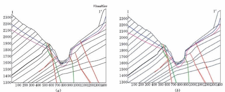
彩图5.1 锦屏一级工程地质Ⅰ—Ⅰ′横剖面对比检查测试
(a)模型剖切剖面;(b)原始解译剖面

彩图5.2 锦屏一级工程地质模型图例
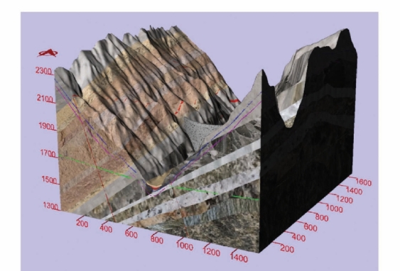
彩图5.3 锦屏一级工程地质三维统一模型(单位:m)
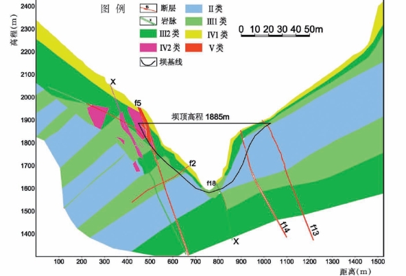
彩图6.1 锦屏一级岩体质量分级坝轴线剖面图
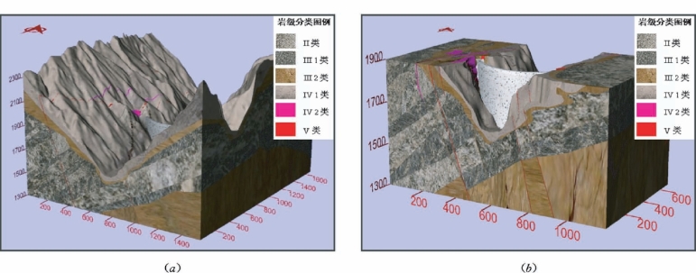
彩图6.2 锦屏一级岩体质量分级三维模型(单位:m)
(a)整体研究区域;(b)拱坝区域
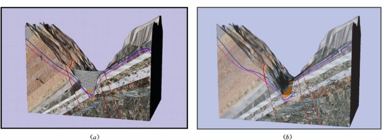
彩图6.3 锦屏一级工程地质三维横剖面图
(a)Ⅱ—Ⅱ′横剖;(b)Ⅱ1—Ⅱ′1横剖
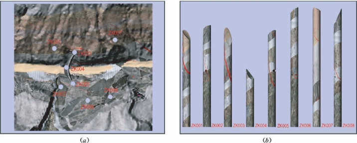
彩图6.4 锦屏一级工程地质钻孔布置与模拟取样
(a)钻孔布置;(b)模拟取样(直径30m)
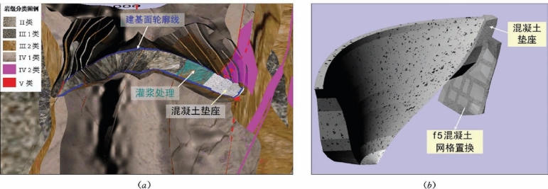
彩图6.5 锦屏一级拱坝建基面开挖与基础处理
(a)建基面开挖;(b)拱坝垫座与断层f5处理
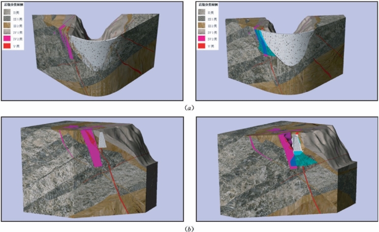
彩图6.6 锦屏一级拱坝基础处理对比分析(坝轴线和径向剖切)
(a)沿坝轴线剖切;(b)沿高程1830m径向剖切
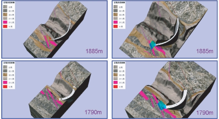
彩图6.7 锦屏一级拱坝基础处理平切对比分析
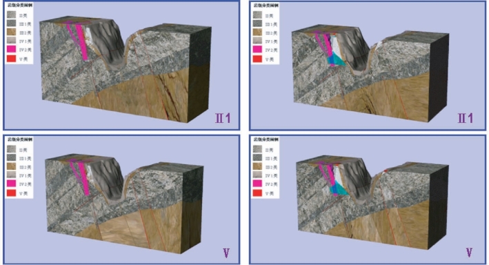
彩图6.8 锦屏一级拱坝基础处理横剖对比分析
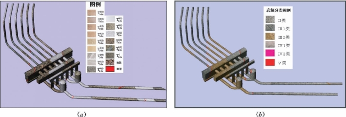
彩图6.9 锦屏一级地下引水发电系统初始方案模型
(a)地下洞室地质模型;(b)地下洞室岩体质量分级模型
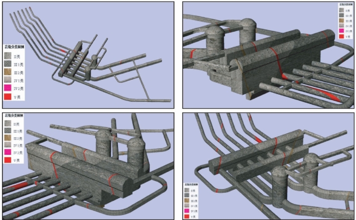
彩图6.10 锦屏一级地下引水发电系统优化方案模型
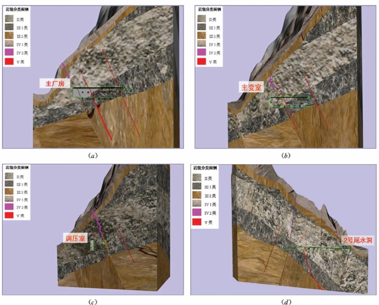
彩图6.11 锦屏一级三维岩级模型地下洞室剖切分析
(a)沿主厂房轴线剖切;(b)沿主变室轴线剖切;(c)沿调压室轴线剖切;(d)沿2号尾水洞轴线剖切
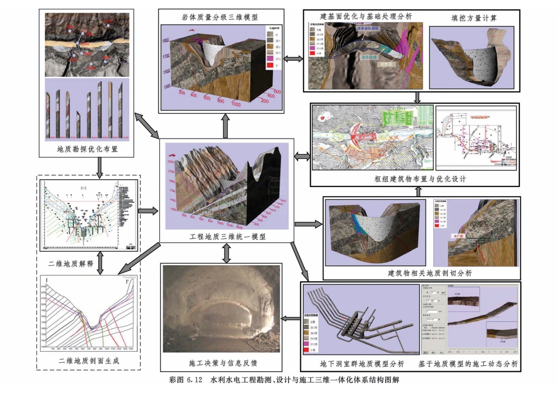
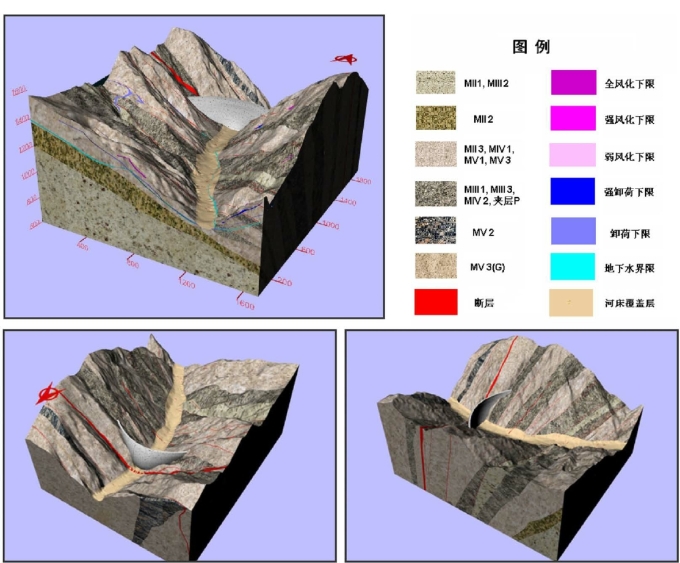
彩图8.1 小湾工程地质三维统一模型
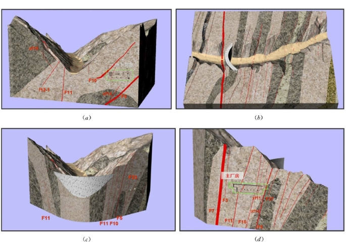
彩图8.2 小湾工程地质三维剖切分析
(a)Ⅱ—Ⅱ横剖面;(b)高程1130m平切;(c)拱坝轴线;(d)主厂房轴线

彩图8.3 小湾地下洞室地质模型分析
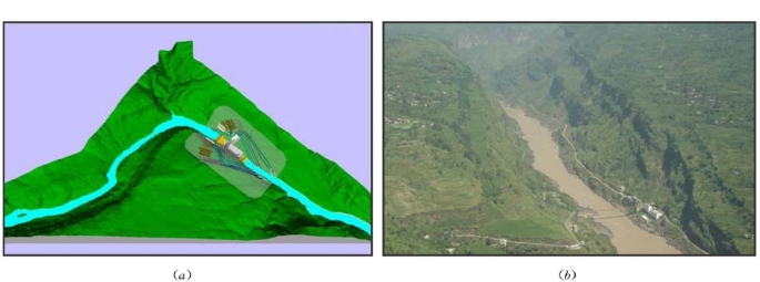
彩图8.4 溪洛渡工程地形地貌
(a)三维数字地形图;(b)坝区地形地貌
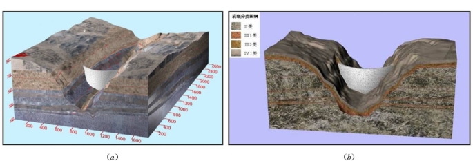
彩图8.5 溪洛渡工程地质和岩级三维模型
(a)地质模型;(b)岩级模型
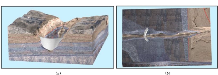
彩图8.6 溪洛渡工程地质三维剖切分析
(a)I7—I7横剖;(b)高程440m平切

彩图8.7 溪洛渡工程岩级三维剖切分析
(a)I3—I3横剖;(b)沿坝轴线
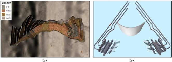
彩图8.8 溪洛渡主体工程地质分析
(a)开挖建基面岩体质量分析;(b)地下厂房地质模型
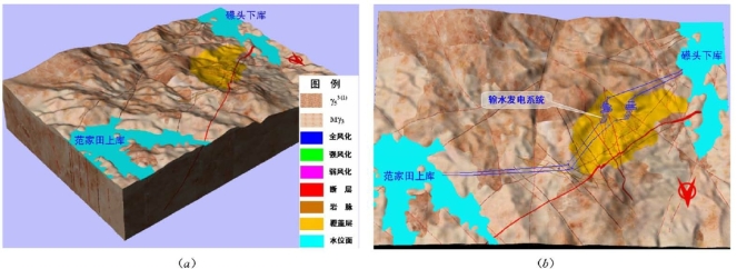
彩图8.9 惠蓄工程地质三维统一模型
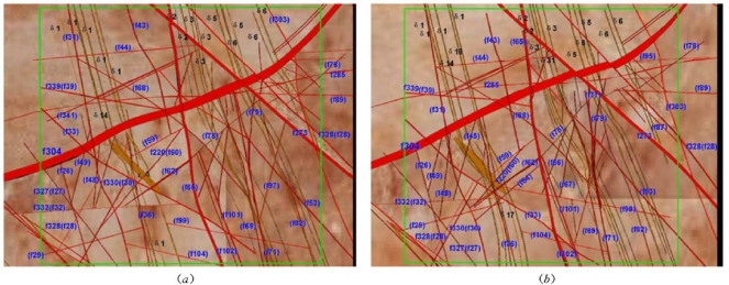
彩图8.10 惠蓄电站厂房区域平切分析
(a)高程135m;(b)高程246m
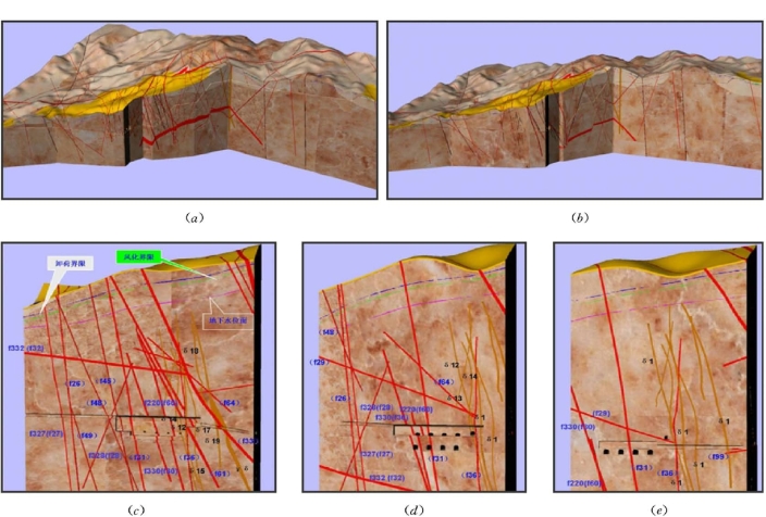
彩图8.11 惠蓄三维统一模型厂区剖切分析
(a)A厂输水系统轴线全剖图;(b)B厂输水系统轴线全剖图;(c)A厂主厂房轴线剖切;(d)A厂主变室轴线剖切;(e)A厂尾闸室轴线剖切
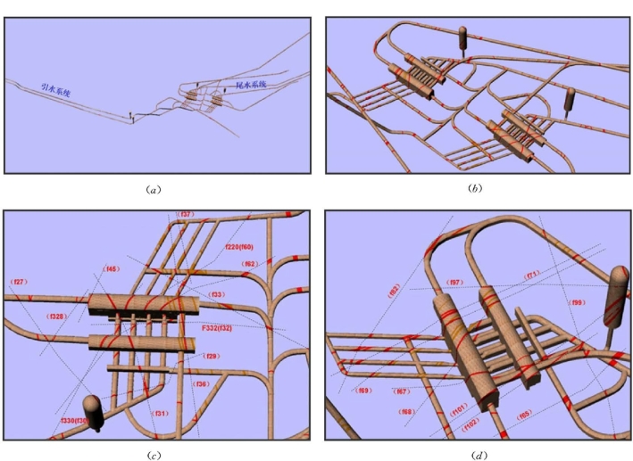
彩图8.12 惠蓄电站地下洞室群地质分析
(a)输水发电系统整体地质模型;(b)A、B系统地下洞室群;(c)A系统地下洞室群;(d)B系统地下洞室群
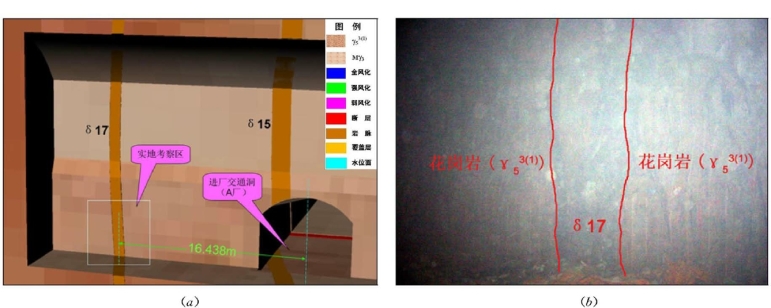
彩图8.13 惠蓄电站地下厂房施工超前地质预报
(a)模型预报;(b)实地开挖照片
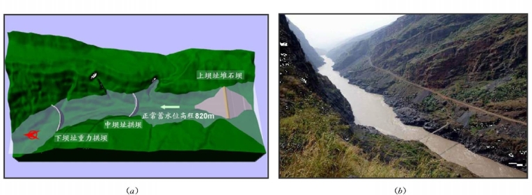
彩图8.14 白鹤滩工程区域地形地貌
(a)三维数字地形;(b)坝址地形地貌
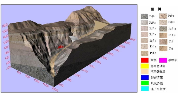
彩图8.15 白鹤滩工程地质三维统一模型(单位:m)
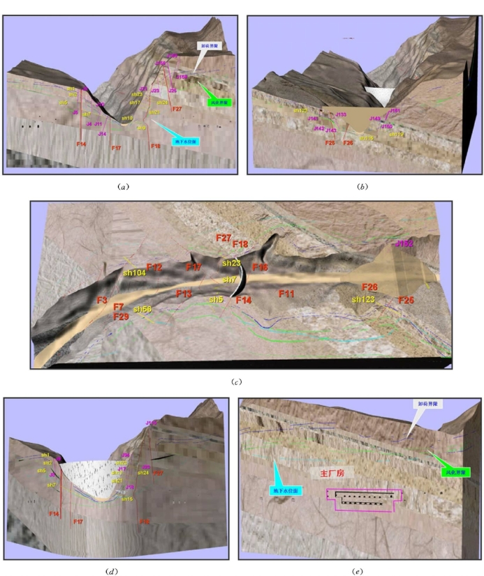
彩图8.16 白鹤滩工程地质典型剖切分析
(a)Ⅰ—Ⅰ横剖;(b)Ⅴ—Ⅴ横剖;(c)高程827m平切;(d)沿中坝址拱坝轴线;(e)沿右岸主厂房轴线

彩图8.17 白鹤滩中坝址地下洞室群三维地质分析
(a)两岸地下洞室群;(b)右岸地下洞室群;(c)左岸地下洞室群
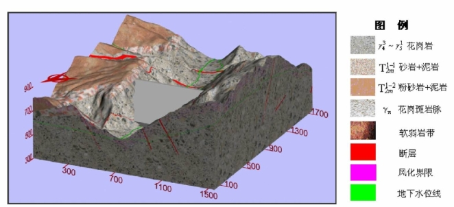
彩图8.18 糯扎渡工程地质三维统一模型(单位:m)
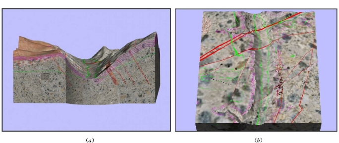
彩图8.19 糯扎渡三维统一模型典型剖切分析
(a)坝轴线剖切;(b)高程650m平切
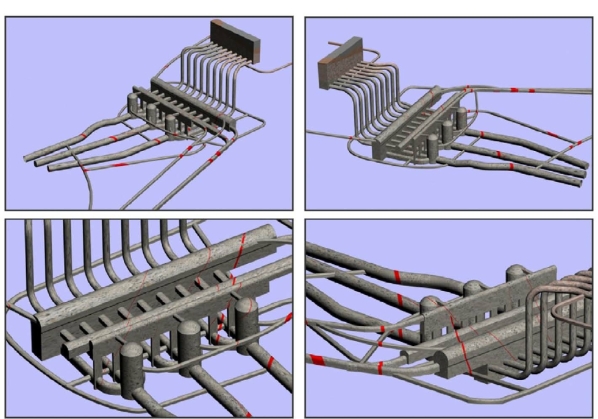
彩图8.20 糯扎渡地下洞室群地质模型分析
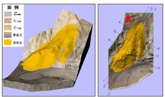
彩图8.21 野猫面滑坡三维地质模型

彩图8.22 野猫面滑坡地质模型剖切分析
(a)2—2′工程地质剖面;(b)高程300m平切图
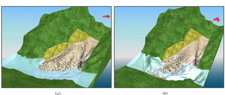
彩图8.23 基于地质模型的野猫面滑坡失稳动态模拟分析
(a)第10s;(b)第50s
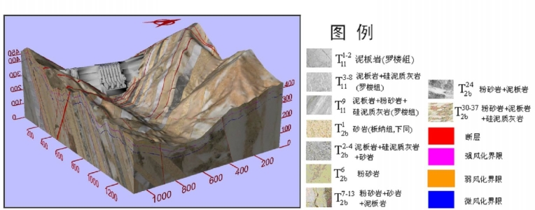
彩图8.24 龙滩工程地质三维统一模型(单位:m)
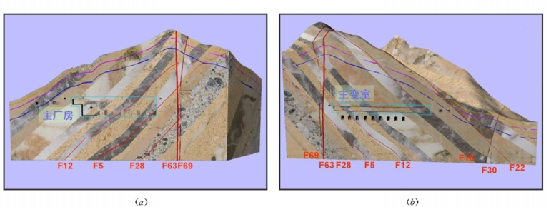
彩图8.25 龙滩工程地质模型剖切分析
(a)沿主厂房轴线剖切;(b)沿主变室轴线剖切
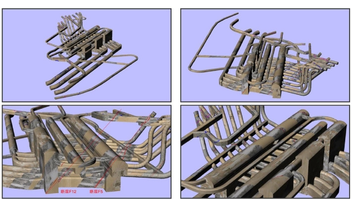
彩图8.26 龙滩地下洞室地质模型分析
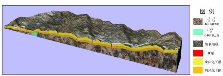
彩图8.27 阿鸠田水电站引水隧洞区域工程地质三维统一模型
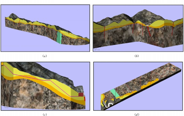
彩图8.28 阿鸠田工程地质模型剖切分析
(a)沿引水隧洞轴线剖切;(b)引水隧洞首部;(c)引水隧洞尾部;(d)高程1050m平切

彩图8.29 八十一大坂隧洞工程地质三维统一模型
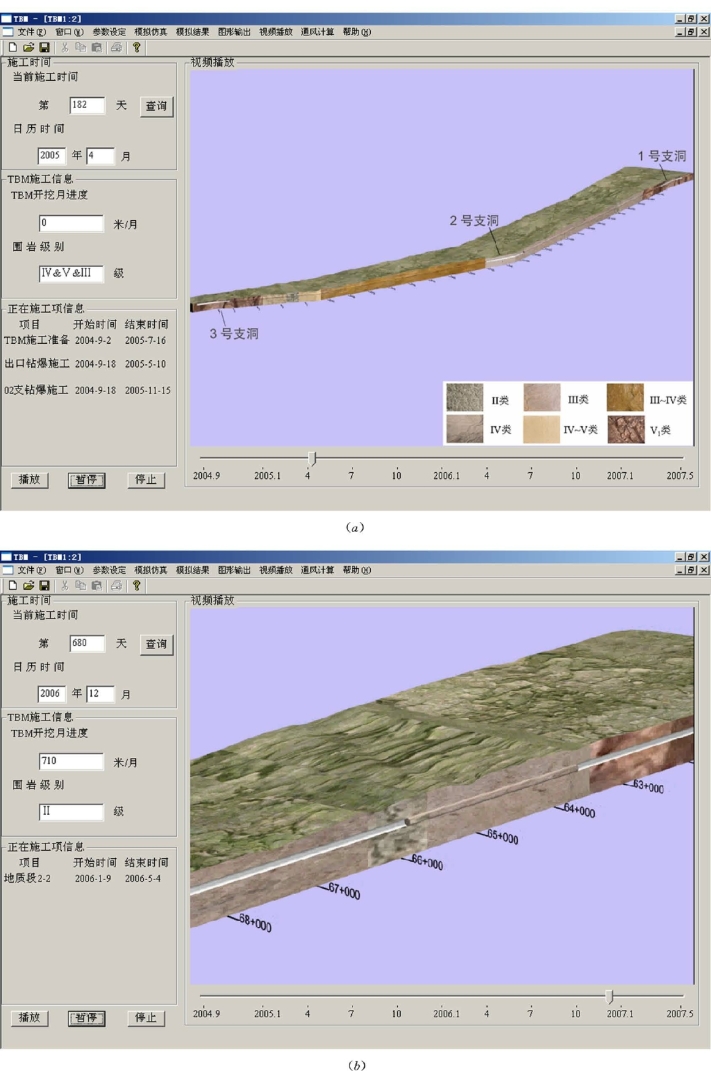
彩图8.30 基于地质模型的八十一大坂隧洞施工动态分析
(a)2005年4月;(b)2006年12月
