13.2.1 Case Description
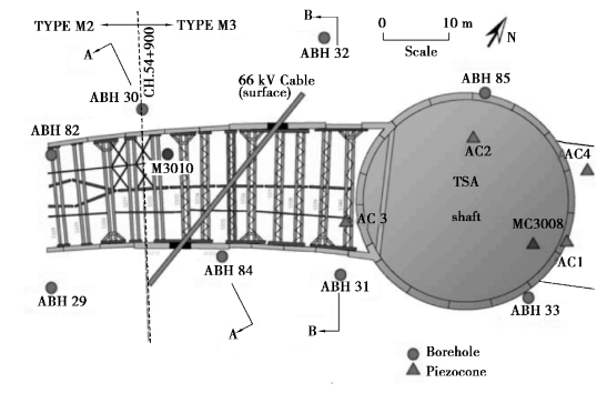
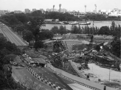
Around 3:30 pm on April 20,2004,the 33.5 m deep cut and cover excavation required for the construction of tunnels between Nicoll Highway and Boulevard Stations(Figures 13.1)collapsed.The collapse was catastrophic,resulting in four fatalities and a lot of damage(Figure 13.2),which delayed the completion of the CCL1 stage by about four years.

Figure 13.1 Plan showing location of diaphragm wall panels,9th level strutting system and site investigation(Whittle A.J.and Davies R.V)

Figure 13.2 The surrounding ground deformation of the collapsed excavation
The Singapore Government appointed a Committee of Inquiry(COI)to ascertain the causes and circumstances of the incident.The COI Report(2005),submitted to the Government in May 2005 and made public on the Internet,is the main source of information for this chapter.
When the incident occurred,the surrounding ground collapsed into the excavation area(Figure 13.2).The area of the collapsed zone was approximately 100 m×130 m and 30 m deep.Its edge was only about 10 m away from the closest building⁃Golden Mile Complex.The Nicoll Highway and the approach slab before the abutment of the Merdeka Bridge over the Kallang River were also damaged.A storm drain located south of the cut and cover tunnel was the main drainage outlet,conveying water to the Kallang River.When the collapse occurred,the river water rushed into the collapse area.Several key utilities,including power electric mains,gas mains,and water mains were broken by the collapse,causing a fire.All this represented a challenge for the following remedial works.
The COI Report states:“Warnings of the approaching collapse were present from an early stage but these were not taken seriously”.Indeed,as early as in August 2003,it became clear that something was wrong with the design.First,in a launch shaft for the tunnel boring machines,across the river east from the collapsed area,wall deflection exceeding 500 mm was measured,while the calculated design level was only 190 mm.This caused damage to the retaining walls,ground settlements and cracks at a cricket field nearby.
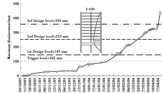
Next,in January 2004,design deflection level was exceeded and cracks appeared in the retaining structures in the cut and cover excavation west of the collapsed area.The design deflection level had to be revised upwards from 222 to 522 mm(from 125 to 313 mm closer to the collapse area).This was accompanied by numerous complaints received from owners of neighboring properties,including ground settlements of a driveway,cracks in buildings and other building damage.Manpower resources from the C824 project team were deployed to handle the repair works.Finally,in the collapsed area itself,the inclinometer I⁃104 indicated that the original design level of 145 mm in the southern diaphragm wall was exceeded as early as February 2004(Figure 13.3).At that moment installation of the sixth strut level was in progress.

Figure 13.3 Displacement of the southern wall in time(After the COI Report,2005):measurements for inclinometer I⁃104(Puzrin et.al.,2010)
The COI concluded,which in our computer⁃dominated age sounds like a paradox:a wrong use of numerical modeling in geotechnical design,together with some structural errors,were the main causes of the Nicoll Highway collapse.
